1990s Maps of Dexter, Delmar Township
Explore 1 historic maps of Dexter from the 1990s. These maps offer a rare glimpse into what life looked like during the 1990s — showing old roads, neighborhoods, homes, and landmarks that have changed or disappeared over time.
Whether you're researching your family's past, planning a metal detecting trip, or studying how Dexter's landscape evolved across the 1990s, these high-resolution maps are a powerful tool for exploring the history of this region.
- Focus on a specific era: All maps on this page are from the 1990s, giving you a focused view of this time period.
- See what’s changed: Compare century-old streets, trails, and buildings to today's modern landscape using overlays and satellite layers.
- Research with precision: Use these maps for genealogy, historical research, land use analysis, or educational projects.
- View, download, or print: Maps are fully viewable online in high resolution, and can be downloaded or printed for your own records.
Start exploring Dexter's history through authentic maps from the 1990s. This is your window into the past.
Dexter, Delmar Township maps
(1)- 1994 Map of Tiadaghton, 1998 Print
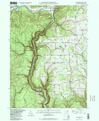 1994 Tiadaghton1998 Print · USGSTioga County's breathtaking canyon country comes into focus in the mid-nineties, showing the intersection of state park conservation and rural plateau life. Genealogists and hikers can trace old landmarks such as Middle Ridge Church, West Branch Cemetery, and the dramatic overlooks at Barbour Rock.
End of results
Showing maps 1-1 of 1
Top cities near Dexter
- Wellsboro historical maps
- Westfield historical maps
- Harrison Township historical maps
- Osceola Township historical maps
- Morris Township historical maps
- Clymer Township historical maps
See more
Frequently asked questions
- What are the different types of historical maps available for Dexter?
- What is the oldest map of Dexter?
- Where can I purchase historical maps of Dexter for my home or office?
- Where can I download high-res historical maps of Dexter?
- Are there historical topographic maps available for Dexter?
- Is there historical aerial imagery available for Dexter?
- Where are historical maps of Dexter sourced from?