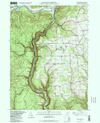
1994 Map of Tiadaghton
USGS Topo · Published 1998About this map
The dramatic Pine Creek Gorge carves through the heart of the Tioga State Forest in this 1990s revision of a mid-century topographic survey. Steep slopes and deep hollows like Beecher Hollow and Mill Hollow frame the winding path of Pine Creek, which is flanked by the public lands of Leonard Harrison State Park and Colton Point State Park. This landscape is defined by its verticality, with lookouts like Barbour Rock and Harrison Lookout providing vantage points over the gorge floor.
Find a feature on this map
57 named features on this map. Tap any name to fly to it.
Don’t see what you’re looking for? This feature index may not catch every label — zoom into the map to look around manually.
Map Details
Editions of this 1994 Tiadaghton Map
This is the sole edition of this map. No revisions or reprints were ever made.
Other maps of this area

1899 · Gaines
USGS Topo · 1:62,500

1900 · Gaines
USGS Topo · 1:62,500

1900 · Elkland
USGS Topo · 1:62,500

1946 · Tiadaghton
USGS Topo · 1:24,000

1946 · Antrim
USGS Topo · 1:62,500

1946 · Cedar Run
USGS Topo · 1:24,000

1946 · Antrim
USGS Topo · 1:24,000

1946 · Morris
USGS Topo · 1:24,000

1947 · Galeton
USGS Topo · 1:62,500

1947 · Lee Fire Tower
USGS Topo · 1:24,000
Featured Places
- Morris Township, PA
- Gaines Township, PA
- Tiadaghton, Delmar Township
- Delmar Township, PA
- Elk Township, PA