Old Maps of Lorenton, Morris Township for Genealogy
Trace your family roots with 12 historic maps of Lorenton. These high-res maps reveal old neighborhoods, homesites, landmarks, and streets — helping you uncover where your ancestors lived and how the area evolved over time.
- Explore historic neighborhoods: Identify where your relatives may have lived in the 1800s or 1900s.
- Compare maps over time: Trace the changes in streets, buildings, and landmarks for multi-generational research.
- Perfect for genealogy & ancestry research: Used by family historians and researchers to map out lineage and migration.
These maps are an incredible resource for exploring your personal connection to Lorenton's past.
Lorenton, Morris Township maps
(12)- 1946 Map of Antrim, 1952 Print
 1946 Antrim1952 Print · USGSTioga County in the years following World War II is defined by the deep carving of Pine Creek Gorge and a network of mountain railroads. Genealogists can trace family roots through remote sites like Antrim Cem, Heise Run Sch, and the Cedar Run Ch.2 unique versions available
 - 1946 Map of Morris, 1965 Print
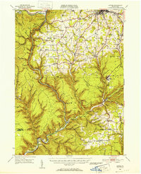
 1946 Morris1965 Print · USGSThe mountain valleys of Tioga County come into focus in the 1940s, centered on the creek-side communities of Morris and Hoytville. Researchers can trace the rural network of family cemeteries like Lewis Cem and upland settlements such as Oregon Hill.3 unique versions available
 - 1950 Map of Morris
 1950 Morris1950 Print · USGSMid-century Tioga County comes alive in this survey of the high hollows and creek valleys surrounding Morris. Genealogists and historians can trace the Erie RR line, locate the Crawford Fire Tower, and explore old rural centers like Hoytville and Oregon Hill.
 - 1954 Map of Williamsport
 1954 Williamsport1954 Print · USGSNorth-central Pennsylvania in the mid-fifties is defined by the winding West Branch Susquehanna River and its industrial valley. Local historians can trace the massive Susquehanna Ordnance Depot and the extensive rail networks of the Pennsylvania Railroad.
 - 1960 Map of Williamsport
 1960 Williamsport1960 Print · USGSNorth-central Pennsylvania in the mid-twentieth century was a vital corridor of rail and river industry stretching from the New York line to the coal regions. Genealogists can trace the rail networks of the Pennsylvania RR and Lehigh Valley RR connecting towns like Williamsport, Towanda, and Lock Haven.
 - 1962 Map of Williamsport, 1966 Print
 1962 Williamsport1966 Print · USGSNorth-central Pennsylvania was a landscape of industrial river hubs and vast state woodlands in the early sixties. Researchers can trace the path of the Pennsylvania Railroad through Williamsport and explore the remote reaches of Bucktail State Park.5 unique versions available
 - 1965 Map of Williamsport
 1965 Williamsport1965 Print · USGSNorth-central Pennsylvania in the mid-1960s is defined by the industrial river towns and vast timberlands of the Allegheny Plateau. Researchers can trace historic rail lines like the Erie Lackawanna and Reading as they thread through Williamsport, Lock Haven, and Jersey Shore.
 - 1966 Map of Williamsport
 1966 Williamsport1966 Print · USGSThe Susquehanna Valley was a hub of transit and industry in the mid-seventies, where the river's West Branch connected major college towns and timberlands. Researchers can trace historical rail lines like the Reading or locate regional landmarks from Jersey Shore to Ricketts Glen State Park.
 - 1977 Map of Morris, 1979 Print
 1977 Morris1979 Print · USGSTioga County agriculture and valley settlements are captured in high detail in the late seventies. Researchers can trace the layout of small communities like Morris and Mt Pleasant or examine the upland farms of Oregon Hill.
 - 1981 Map of Wellsboro, 1982 Print
 1981 Wellsboro1982 Print · USGSNorthern Pennsylvania in the early eighties shows a landscape of deep river gorges and vast state forests. Trace the rail lines of Conrail and explore old settlements from Coudersport to the Pine Creek Gorge.
 - 1994 Map of Morris, 1999 Print
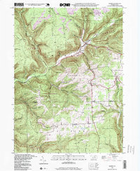 1994 Morris1999 Print · USGSThe Pennsylvania backcountry near the Tioga and Lycoming border is captured here in the 1990s, centered on the valley hamlets of Morris and Hoytville. Researchers can trace old mountain roads and local landmarks like Lewis Cem and the Crawford Fire Tower.
 - 2023 Map of Morris, 2023 Print
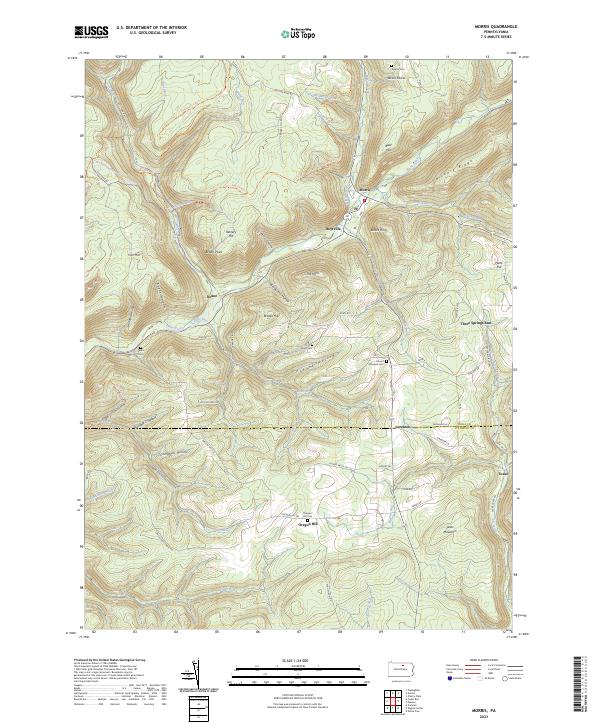 2023 Morris2023 Print · USGSTioga County highlands meet the Lycoming border in the early 2020s, showing the enduring valley settlements along Babb Creek. Genealogists can trace family footprints at Antrim Cem, Mount Pleasant Cem, and the historic crossroads of Oregon Hill.
End of results
Showing maps 1-12 of 12
Top cities near Lorenton
- Wellsboro historical maps
- Blossburg historical maps
- Covington historical maps
- Morris Township historical maps
- Gaines Township historical maps
- Gallagher Township historical maps
See more
Frequently asked questions
- What are the different types of historical maps available for Lorenton?
- What is the oldest map of Lorenton?
- Where can I purchase historical maps of Lorenton for my home or office?
- Where can I download high-res historical maps of Lorenton?
- Are there historical topographic maps available for Lorenton?
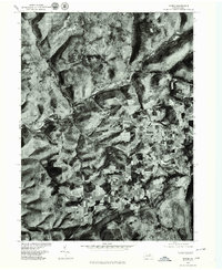
- Is there historical aerial imagery available for Lorenton?
- Where are historical maps of Lorenton sourced from?