1940s Maps of Warren County, Pennsylvania
Explore 5 historic maps of Warren County from the 1940s. These maps offer a rare glimpse into what life looked like during the 1940s — showing old roads, neighborhoods, homes, and landmarks that have changed or disappeared over time.
Whether you're researching your family's past, planning a metal detecting trip, or studying how Warren County's landscape evolved across the 1940s, these high-resolution maps are a powerful tool for exploring the history of this region.
- Focus on a specific era: All maps on this page are from the 1940s, giving you a focused view of this time period.
- See what’s changed: Compare century-old streets, trails, and buildings to today's modern landscape using overlays and satellite layers.
- Research with precision: Use these maps for genealogy, historical research, land use analysis, or educational projects.
- View, download, or print: Maps are fully viewable online in high resolution, and can be downloaded or printed for your own records.
Start exploring Warren County's history through authentic maps from the 1940s. This is your window into the past.
Warren County, PA maps
(5)- 1941 Map of Sheffield
 1941 Sheffield1941 Print · USGSForest and Warren Counties are seen here during the early 1940s, a period when local logging and oil activities shaped the landscape. Researchers can trace the Tionesta Valley RR and find remote outposts like Pigeon PO or Seldom Seen Cors.2 unique versions available
 - 1941 Map of Kinzua
 1941 Kinzua1941 Print · USGSThe Allegheny River valley and the Cornplanter Indian Reservation are shown here in the years before mid-century dam projects forever changed the landscape. Researchers can trace the river-level Pennsylvania Railroad, the Kinzua Coal Mine, and now-submerged settlements like Kinzua and Corydon.3 unique versions available
 - 1943 Map of Youngsville
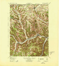 1943 Youngsville1943 Print · USGSThe valleys and ridges of Warren County appear in detail during the early 1940s, highlighting the rail-to-river economy along the Allegheny River. Genealogists can trace family roots through numerous hill schools and rural churches like Davy Hill Ch and Vankirkbush Sch.
 - 1947 Map of Cherry Grove, 1972 Print
 1947 Cherry Grove1972 Print · USGSPotter County's high forest plateaus are captured here as they appeared in the late forties and early seventies. Researchers can trace the old Coudersport and Port Allegany Railroad and locate the Cherry Springs Fire Tower.
 - 1949 Map of Kinzua, 1954 Print
 1949 Kinzua1954 Print · USGSThe Allegheny River valley remains the heart of this region in the late 1940s, just before major changes altered the landscape. Researchers can trace riverside life in Kinzua and Corydon or locate the historic Cornplanter Indian Reservation.4 unique versions available
End of results
Showing maps 1-5 of 5
Top cities of Warren County
- Warren historical maps
- Sheffield Township historical maps
- Youngsville historical maps
- Pittsfield Township historical maps
- Spring Creek Township historical maps
- Tidioute historical maps
See more
Frequently asked questions
- What are the different types of historical maps available for Warren County?
- What is the oldest map of Warren County?
- Where can I purchase historical maps of Warren County for my home or office?
- Where can I download high-res historical maps of Warren County?
- Are there historical topographic maps available for Warren County?
- Is there historical aerial imagery available for Warren County?
- Where are historical maps of Warren County sourced from?