1920s Maps of Eldred Township, Pennsylvania
Explore 5 historic maps of Eldred Township from the 1920s. These maps offer a rare glimpse into what life looked like during the 1920s — showing old roads, neighborhoods, homes, and landmarks that have changed or disappeared over time.
Whether you're researching your family's past, planning a metal detecting trip, or studying how Eldred Township's landscape evolved across the 1920s, these high-resolution maps are a powerful tool for exploring the history of this region.
- Focus on a specific era: All maps on this page are from the 1920s, giving you a focused view of this time period.
- See what’s changed: Compare century-old streets, trails, and buildings to today's modern landscape using overlays and satellite layers.
- Research with precision: Use these maps for genealogy, historical research, land use analysis, or educational projects.
- View, download, or print: Maps are fully viewable online in high resolution, and can be downloaded or printed for your own records.
Start exploring Eldred Township's history through authentic maps from the 1920s. This is your window into the past.
Eldred Township, PA maps
(5)- 1926 Map of Youngsville, 1961 Print
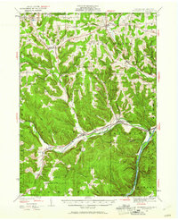 1926 Youngsville1961 Print · USGSWarren County at the dawn of the motorized age shows a landscape of small valley towns and isolated hill farms. Local researchers can trace old schoolhouse locations like White Sch and family-named landmarks such as Pikes Rocks and Cole Hill Fire Tower.
 - 1927 Map of Tidioute
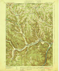
 1927 Tidioute1927 Print · USGSThe Allegheny River valley was a bustling corridor of rail and river industry in the late twenties. Genealogists can trace family footprints across dozens of local schoolhouses like Triumph Sch and rural hubs such as Endeavor or East Hickory.4 unique versions available
 - 1927 Map of Titusville, 1958 Print
 1927 Titusville1958 Print · USGSThe oil region of northwestern Pennsylvania is captured here in the late 1920s, centered on the industrial and rail hub of Titusville. Genealogists and researchers can locate the historic Drake Oil Well, dozens of country schools like Fink Ridge Sch, and the local Harrison Cem.3 unique versions available
 - 1929 Map of Corry
 1929 Corry1929 Print · USGSThe industrial hub of Corry and the rural expanses of Erie and Crawford counties are captured here just before the Great Depression. Genealogists can trace family roots through numerous remote schools and churches, from Harbor Hall Ch to the tiny settlement of Hatchtown.2 unique versions available
 - 1929 Map of Youngsville
 1929 Youngsville1929 Print · USGSWarren County at the close of the twenties shows a landscape of busy rail junctions and upland farm communities. You can trace early family sites through dozens of named schoolhouses like Yankebush Sch, find the Cole Hill Fire Tower, or follow the Erie RR through Bear Lake.5 unique versions available
End of results
Showing maps 1-5 of 5
Top cities near Eldred Township
- Corry historical maps
- Titusville historical maps
- Columbus historical maps
- Cherrytree Township historical maps
- Pittsfield Township historical maps
- Spring Creek Township historical maps
See more
Top neighborhoods of Eldred Township
- Sanford historical maps
- Eldred Center historical maps
- Fiddlergreen historical maps
- Grand Valley historical maps
- Starr historical maps
Frequently asked questions
- What are the different types of historical maps available for Eldred Township?
- What is the oldest map of Eldred Township?
- Where can I purchase historical maps of Eldred Township for my home or office?
- Where can I download high-res historical maps of Eldred Township?
- Are there historical topographic maps available for Eldred Township?
- Is there historical aerial imagery available for Eldred Township?
- Where are historical maps of Eldred Township sourced from?