1990s Maps of Enon, East Finley Township
Explore 1 historic maps of Enon from the 1990s. These maps offer a rare glimpse into what life looked like during the 1990s — showing old roads, neighborhoods, homes, and landmarks that have changed or disappeared over time.
Whether you're researching your family's past, planning a metal detecting trip, or studying how Enon's landscape evolved across the 1990s, these high-resolution maps are a powerful tool for exploring the history of this region.
- Focus on a specific era: All maps on this page are from the 1990s, giving you a focused view of this time period.
- See what’s changed: Compare century-old streets, trails, and buildings to today's modern landscape using overlays and satellite layers.
- Research with precision: Use these maps for genealogy, historical research, land use analysis, or educational projects.
- View, download, or print: Maps are fully viewable online in high resolution, and can be downloaded or printed for your own records.
Start exploring Enon's history through authentic maps from the 1990s. This is your window into the past.
Enon, East Finley Township maps
(1)- 1997 Map of Wind Ridge, 1999 Print
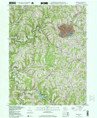 1997 Wind Ridge1999 Print · USGSSouthwestern Pennsylvania's rural hill country is mapped here in the late nineties, showing the transition between Greene and Washington counties. Genealogists can locate family burial grounds like Zollars Cem and trace the area surrounding the Jacktown Fairgrounds.
End of results
Showing maps 1-1 of 1
Top cities near Enon
- Wheeling historical maps
- Washington historical maps
- South Strabane Township historical maps
- Waynesburg historical maps
- East Washington historical maps
- Independence Township historical maps
See more
Frequently asked questions
- What are the different types of historical maps available for Enon?
- What is the oldest map of Enon?
- Where can I purchase historical maps of Enon for my home or office?
- Where can I download high-res historical maps of Enon?
- Are there historical topographic maps available for Enon?
- Is there historical aerial imagery available for Enon?
- Where are historical maps of Enon sourced from?