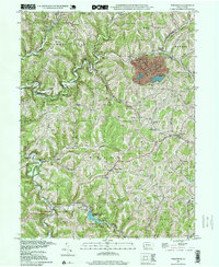
1997 Map of Wind Ridge
USGS Topo · Published 1999About this map
Ryerson Station State Park anchors the southern portion of this landscape, centered on the Ryerson Station Reservoir at the confluence of the North Fork and South Fork. The terrain is defined by a dense network of steep hollows and ridges, such as Stone Coal Hill, which separate small agricultural and residential nodes. The local identity of this region in the late 1990s is tied to traditional gatherings and rural infrastructure, evidenced by the Jacktown Fairgrounds and a Covered Bridge crossing the Enlow Fork near Burdette. Genealogy researchers will find several family-named burial sites including Zollars Cem, Braddock Cem, and Lazear Cem. Small hamlets like Wind Ridge and West Finley are scattered throughout, connected by winding roads that follow the contours of the Dunkard Fork and Templeton Fork.
Find a feature on this map
51 named features on this map. Tap any name to fly to it.
Don’t see what you’re looking for? This feature index may not catch every label — zoom into the map to look around manually.
Map Details
Editions of this 1997 Wind Ridge Map
This is the sole edition of this map. No revisions or reprints were ever made.
Other maps of this area

1902 · Wheeling
USGS Topo · 1:62,500

1904 · Cameron
USGS Topo · 1:62,500

1905 · Rogersville
USGS Topo · 1:62,500

1907 · Claysville
USGS Topo · 1:62,500

1935 · Cameron
USGS Topo · 1:62,500

1935 · Wheeling
USGS Topo · 1:62,500

1942 · Cameron
USGS Topo · 1:62,500

1942 · Wheeling
USGS Topo · 1:62,500

1949 · Clarksburg
USGS Topo · 1:250,000

1951 · Canton
USGS Topo · 1:250,000