
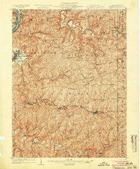
1935 Map of Wheeling
USGS Topo · Published 1957About this map
The Ohio River corridor serves as the industrial and transportation backbone of this mid-1930s landscape, connecting bustling Ohio settlements like Martins Ferry and Tiltonville with the West Virginia riverfront. The city of Wheeling is shown in detail, including its expansion onto Wheeling Island and the cluster of institutions such as Mt de Chantal and Wheeling Park. Inland, the terrain is defined by the winding paths of Buffalo Creek and Wheeling Creek, where smaller communities like West Liberty and Bethany are located.
Find a feature on this map
129 named features on this map. Tap any name to fly to it.
Don’t see what you’re looking for? This feature index may not catch every label — zoom into the map to look around manually.
Map Details
Editions of this 1935 Wheeling Map
This is the sole edition of this map. No revisions or reprints were ever made.
Other maps of this area

1901 · Cadiz
USGS Topo · 1:62,500

1902 · Wheeling
USGS Topo · 1:62,500

1903 · Cadiz
USGS Topo · 1:62,500

1904 · Steubenville
USGS Topo · 1:62,500
1904 · Cameron
USGS Topo · 1:62,500

1904 · Burgettstown
USGS Topo · 1:62,500

1905 · Rogersville
USGS Topo · 1:62,500
1905 · Clarington
USGS Topo · 1:62,500

1905 · St. Clairsville
USGS Topo · 1:62,500

1906 · Burgettstown
USGS Topo · 1:62,500