Old Maps of Westmoreland County, Pennsylvania for Hiking & Exploration
Hike through history with 145 historic maps of Westmoreland County. Explore old trails, ghost towns, and forgotten backroads — perfect for outdoor adventurers and local explorers.
- Rediscover forgotten places: Map out old mining camps, roads, and footpaths that no longer exist on modern maps.
- Layer with modern tools: Combine with LiDAR or satellite views to plan hikes through historical terrain.
- Made for exploration: Popular among hikers, overlanders, and local history lovers.
Use these maps to find adventure and explore the hidden past of Westmoreland County.
Westmoreland County, PA maps
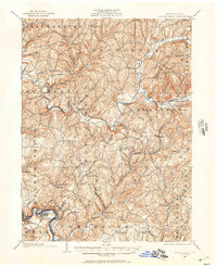
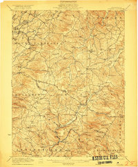
(145)- 1900 Map of Latrobe, 1958 Print
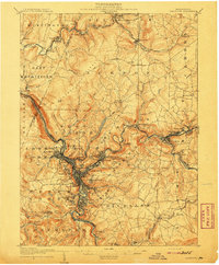
 1900 Latrobe1958 Print · USGSThe industrial heart of Westmoreland County is shown at a pivotal moment when the coal and coke industry was reshaping the land. Genealogists and historians can trace the early layouts of Latrobe, Derry, and Blairsville alongside company towns like Whitney and Baggaley.
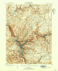
 - 1902 Map of Latrobe
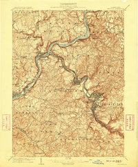
 1902 Latrobe1902 Print · USGSWestmoreland County at the opening of the twentieth century was a powerhouse of the American coal and coke industry. Genealogists and industrial historians can trace the early rail networks of the Main Line and locate landmark sites like the St Vincent Monastery and various Coke Ovens.
 - 1902 Map of Brownsville
 1902 Brownsville1902 Print · USGSThe Monongahela Valley was a powerhouse of Pennsylvania industry at the start of the twentieth century, defined by its coal mines and river-front rail lines. Researchers can trace the heritage of the National Pike and locate vanished works at Vesta Mine or Coal Bluff.
 - 1902 Map of Connellsville
 1902 Connellsville1902 Print · USGSThe Pennsylvania coke region comes alive at the turn of the century as a labyrinth of coal mines and competing rail lines. Researchers can trace the industrial footprint of Star Mines, explore the river landings along the Youghiogheny River, and find old junctions like Bells Mills.5 unique versions available
 - 1902 Map of Elders Ridge, 1957 Print
 1902 Elders Ridge1957 Print · USGSWestern Pennsylvania at the turn of the century reveals a landscape of deep valleys and rising industrial rail lines. Genealogists can trace family roots through rural hubs like Brick Church, Elderton, and the namesake village of Elders Ridge.2 unique versions available
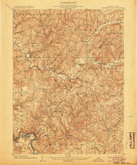
 - 1903 Map of Latrobe, 1905 Print
 1903 Latrobe1905 Print · USGSWestmoreland County at the turn of the century reveals a landscape defined by the arrival of heavy industry and the winding Conemaugh River. Genealogists can locate family landmarks from the Coke Ovens at Crabtree to the grounds of St. Vincent.6 unique versions available
 - 1904 Map of Elders Ridge
 1904 Elders Ridge1904 Print · USGSArmstrong and Indiana Counties are shown here during the early 1900s, when the river-and-rail economy dominated the valley floor. Researchers can trace ancestral roots through rural hamlets like Elders Ridge, Cochran Mills, and Shelocta, or follow the Western Pennsylvania Division (P. R. R.) along the Kiskiminitas River.5 unique versions available
 - 1904 Map of Mc Keesport
 1904 Mc Keesport1904 Print · USGSAllegheny County at the height of its industrial era reveals a landscape of massive rail yards and riverfront steel towns. Genealogists can trace family roots through dense neighborhoods in Homestead, Wilkinsburg, and Braddock or locate ancestral plots in Homewood Cem.2 unique versions available
 - 1904 Map of Johnstown, 1954 Print
 1904 Johnstown1954 Print · USGSJohnstown and the Cambria County coalfields are shown in detail during their industrial peak in the early twentieth century. Researchers can trace ancestral neighborhoods like Morrellville and Franklin, or locate historic landmarks such as the Old Portage RR Tunnel and Grandview Cemetery.2 unique versions available
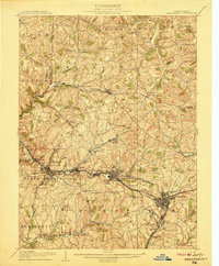
 - 1904 Map of Greensburg, 1963 Print
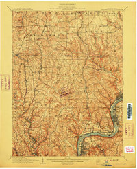
 1904 Greensburg1963 Print · USGSWestmoreland County at the dawn of the twentieth century was a landscape of industrial power and small-town growth. Genealogists can trace family footprints through Greensburg, find the Bulltown Schoolhouse, or follow the Pennsylvania Railroad through Jeannette and Manor.
 - 1906 Map of Brownsville
 1906 Brownsville1906 Print · USGSSouthwestern Pennsylvania’s river valleys were centers of industrial expansion when this survey was conducted. Genealogists can locate family homes and landmarks in riverfront towns like Monessen and Charleroi, or trace rural roots near Salem Church and Ginger Hill.4 unique versions available
 - 1906 Map of Greensburg
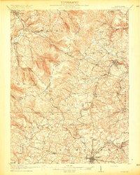
 1906 Greensburg1906 Print · USGSWestmoreland County at the height of its industrial growth is detailed here, showing a landscape defined by coal, glass, and rail. Researchers can trace ancestral roots at the Bulltown Schoolhouse or follow the early trolley and rail lines through Jeannette and Export.6 unique versions available
 - 1907 Map of Johnstown
 1907 Johnstown1907 Print · USGSJohnstown and the surrounding coal valleys are captured here at the height of their industrial expansion in the early twentieth century. Researchers can trace the path of the Pennsylvania RR and find vanished local landmarks like Expedit PO and the Old Portage RR Tunnel.6 unique versions available
 - 1907 Map of Pittsburg
 1907 Pittsburg1907 Print · USGSSteel-industry heartlands and river-valley rail corridors define the Pittsburgh region in the early nineteen-hundreds. Trace the complex rail networks of the Union RR and Pennsylvania RR through industrial hubs like Homestead and Wilmerding.10 unique versions available
 - 1907 Map of Freeport, 1956 Print
 1907 Freeport1956 Print · USGSThe industrial river valleys of Armstrong, Westmoreland, and Butler counties come alive in this early 1900s survey. Genealogists and researchers can trace the rail-and-river network through Freeport and Schenley, locating old post offices at Garvers Ferry and Dime.
 - 1908 Map of New Kensington, 1956 Print
 1908 New Kensington1956 Print · USGSThe Allegheny River valley and its surrounding townships are captured here at the start of the twentieth century. Researchers can trace early railroad stops at Allison Park Sta, find rural landmarks like Sandy Hill School, and locate the Fulton Ferry crossing.
 - 1909 Map of Freeport
 1909 Freeport1909 Print · USGSThe industrial river valleys of the Allegheny and Kiskiminitas are captured here during the peak of Pennsylvania's rail-and-river era. Researchers can trace the early layouts of Freeport and Leechburg or locate vanished sites like the Lucesco PO.5 unique versions available
 - 1910 Map of New Kensington
 1910 New Kensington1910 Print · USGSThe industrial Allegheny River corridor and its rugged hinterlands come alive in this 1910 survey of the Westmoreland and Butler County borders. Genealogists and historians can trace family roots through labels for Sandy Hill School, Clinton Church, and the settlement at Saxonburg.7 unique versions available
 - 1913 Map of Somerset, 1961 Print
 1913 Somerset1961 Print · USGSSomerset County was a rugged crossroads of rail and mountain ridges in the decade before the First World War. Local historians can trace the Pittsburgh and Philadelphia Road and find vanished local landmarks like Rectors Mill, the Quemahoning Tunnel, and Sipesville Station.
 - 1915 Map of Somerset
 1915 Somerset1915 Print · USGSSomerset and the surrounding Laurel Ridge region are captured here during the peak of the early twentieth-century coal boom. Genealogists and historians can trace family-named sites and industrial landmarks including Husband Mine, Rectors Mill, and the Quemahoning Tunnel.6 unique versions available
 - 1920 Map of New Florence, 1958 Print
 1920 New Florence1958 Print · USGSThe Conemaugh River valley at the dawn of the 1920s shows a landscape defined by the PENNSYLVANIA RR and industrial coal towns. Genealogists can locate family homesteads near dozens of named country schools like Wallace School or trace the old Lincoln Highway through Armagh.
 - 1921 Map of New Florence
 1921 New Florence1921 Print · USGSWestmoreland and Indiana counties are captured in the early 1920s as industrial rail corridors and the Lincoln Highway begin to modernize the rural landscape. Genealogists can locate family landmarks like Campbell's Mill, the Centerville Huff PO, and several country schools including Robbs School.
 - 1922 Map of Donegal
 1922 Donegal1922 Print · USGSWestmoreland and Fayette counties are captured here in the early twenties, showing a landscape of mountain ridges and busy valley crossroads. Genealogists can trace family roots through dozens of rural landmarks like St Boniface Chapel, Hoods Mill, and the Snowball School.2 unique versions available
 - 1922 Map of New Florence
 1922 New Florence1922 Print · USGSWestern Pennsylvania in the early 1920s shows a landscape of river-carved ridges and busy rail corridors connecting coal and quarry towns. Genealogists can trace family footprints across dozens of rural schools and stations like Lockport Station, Centerville (Huff PO), and Grafton.5 unique versions available
 - 1931 Map of Brownsville, 1954 Print
 1931 Brownsville1954 Print · USGSThe industrial Monongahela and Youghiogheny river valleys are captured here in the early thirties, showcasing a landscape of coal mines and river locks. Genealogists can trace family homes near Vesta Mine, Sutersville, and rural landmarks like Salem Church.
Showing maps 1-25 of 145
Top cities of Westmoreland County
- Greensburg historical maps
- New Kensington historical maps
- Lower Burrell historical maps
- Jeannette historical maps
- Latrobe historical maps
- Monessen historical maps
See more
Frequently asked questions
- What are the different types of historical maps available for Westmoreland County?
- What is the oldest map of Westmoreland County?
- Where can I purchase historical maps of Westmoreland County for my home or office?
- Where can I download high-res historical maps of Westmoreland County?
- Are there historical topographic maps available for Westmoreland County?
- Is there historical aerial imagery available for Westmoreland County?
- Where are historical maps of Westmoreland County sourced from?