1910s Maps of Ligonier, Pennsylvania
Explore 2 historic maps of Ligonier from the 1910s. These maps offer a rare glimpse into what life looked like during the 1910s — showing old roads, neighborhoods, homes, and landmarks that have changed or disappeared over time.
Whether you're researching your family's past, planning a metal detecting trip, or studying how Ligonier's landscape evolved across the 1910s, these high-resolution maps are a powerful tool for exploring the history of this region.
- Focus on a specific era: All maps on this page are from the 1910s, giving you a focused view of this time period.
- See what’s changed: Compare century-old streets, trails, and buildings to today's modern landscape using overlays and satellite layers.
- Research with precision: Use these maps for genealogy, historical research, land use analysis, or educational projects.
- View, download, or print: Maps are fully viewable online in high resolution, and can be downloaded or printed for your own records.
Start exploring Ligonier's history through authentic maps from the 1910s. This is your window into the past.
Ligonier, PA maps
(2)- 1913 Map of Somerset, 1961 Print
 1913 Somerset1961 Print · USGSSomerset County was a rugged crossroads of rail and mountain ridges in the decade before the First World War. Local historians can trace the Pittsburgh and Philadelphia Road and find vanished local landmarks like Rectors Mill, the Quemahoning Tunnel, and Sipesville Station.
 - 1915 Map of Somerset
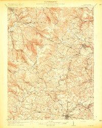 1915 Somerset1915 Print · USGSSomerset and the surrounding Laurel Ridge region are captured here during the peak of the early twentieth-century coal boom. Genealogists and historians can trace family-named sites and industrial landmarks including Husband Mine, Rectors Mill, and the Quemahoning Tunnel.6 unique versions available
End of results
Showing maps 1-2 of 2
Top cities near Ligonier
- Latrobe historical maps
- Somerset historical maps
- Blairsville historical maps
- Derry historical maps
- Loyalhanna historical maps
- Brush Valley Township historical maps
See more
Frequently asked questions
- What are the different types of historical maps available for Ligonier?
- What is the oldest map of Ligonier?
- Where can I purchase historical maps of Ligonier for my home or office?
- Where can I download high-res historical maps of Ligonier?
- Are there historical topographic maps available for Ligonier?
- Is there historical aerial imagery available for Ligonier?
- Where are historical maps of Ligonier sourced from?