1940s Maps of York County, Pennsylvania
Explore 15 historic maps of York County from the 1940s. These maps offer a rare glimpse into what life looked like during the 1940s — showing old roads, neighborhoods, homes, and landmarks that have changed or disappeared over time.
Whether you're researching your family's past, planning a metal detecting trip, or studying how York County's landscape evolved across the 1940s, these high-resolution maps are a powerful tool for exploring the history of this region.
- Focus on a specific era: All maps on this page are from the 1940s, giving you a focused view of this time period.
- See what’s changed: Compare century-old streets, trails, and buildings to today's modern landscape using overlays and satellite layers.
- Research with precision: Use these maps for genealogy, historical research, land use analysis, or educational projects.
- View, download, or print: Maps are fully viewable online in high resolution, and can be downloaded or printed for your own records.
Start exploring York County's history through authentic maps from the 1940s. This is your window into the past.
York County, PA maps
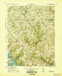
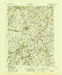
(15)- 1942 Map of Havre De Grace
 1942 Havre De Grace1942 Print · USGSThe Susquehanna riverfront and Mason-Dixon borderlands are captured here in the early 1940s, just as modern infrastructure began to reshape the region. Genealogists can trace family roots through landmarks like Smith Chapel, Lees Mill, and the Brookview Cem near Rising Sun.4 unique versions available
 - 1942 Map of Bel Air
 1942 Bel Air1942 Print · USGSHarford and York counties at the start of the 1940s show a landscape shaped by the Maryland and Pennsylvania R.R. and deep-cut creek valleys. Trace the local rail-and-mill economy through Clermont Mills, Whiteford, and the village of Delta near the state line.
 - 1942 Map of Gettysburg, 1944 Print
 1942 Gettysburg1944 Print · USGSGettysburg and its surrounding borderlands are shown in great detail during the early 1940s, capturing the region's dense network of rural schools and mills. Genealogists can trace family-named landmarks such as Galt Kump PO, Hafers Mill, and Philips Delight Sch.
 - 1943 Map of New Cumberland
 1943 New Cumberland1943 Print · USGSGreater Harrisburg and the lower Susquehanna valley appear here in the midst of the Second World War, showing a landscape of intense military and social transition. Researchers can trace family roots through numerous country landmarks like Eberlys Mill, the Methodist Orphanage, and Messiah Bible College.
 - 1943 Map of Middletown
 1943 Middletown1943 Print · USGSAs World War II mobilization reached its peak, this survey captures the Susquehanna River corridor as a vital industrial and rail artery. Genealogists and researchers can trace family landmarks like Donegal Springs Church, Codorus Furnace, and the early layout of Three Mile Island.
 - 1943 Map of Mc Calls Ferry
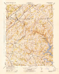
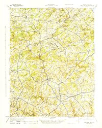
 1943 Mc Calls Ferry1943 Print · USGSMid-century Pennsylvania life unfolds along the Susquehanna during the 1940s, where river-based industry and rail lines meet established farming townships. Researchers can trace ancestral locations from Washington Boro to rural landmarks like Erbs Mill, Bethel Church, and the Red Hill School.2 unique versions available
 - 1943 Map of Carlisle, 1944 Print
 1943 Carlisle1944 Print · USGSCumberland County during the mid-forties reveals a landscape transitioning between its deep industrial roots and new high-speed transit. Genealogists and historians can trace family locations through numerous rural landmarks like Farmers Academy, Reading Banks, and the Carlisle Barracks.3 unique versions available
 - 1944 Map of New Freedom
 1944 New Freedom1944 Print · USGSThe Pennsylvania-Maryland border during the mid-forties reveals a rural landscape of tight-knit communities centered on the Pennsylvania Railroad. Genealogists and historians can trace the foundations of local life through the Summit Grove Camp Meeting, Bentley Springs, and the 6th District Consolidated School.
 - 1944 Map of Manchester
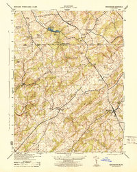 1944 Manchester1944 Print · USGSThe Pennsylvania-Maryland border country was a landscape of mill seats and rural schools in the 1940s. Genealogists and historians can trace the Mason And Dixon Line past Bachman Mills, Hoffackers School, and St Bartholomew Church.
 - 1944 Map of Norrisville
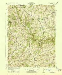 1944 Norrisville1944 Print · USGSMaryland and Pennsylvania borderlands meet along the Mason and Dixon Line during the mid-1940s. Genealogists and researchers can trace rural life through landmarks like Ivory Mill, Ebaughs School, and the McKendree Church.
 - 1944 Map of Lineboro
 1944 Lineboro1944 Print · USGSMaryland and Pennsylvania border life is captured here in the mid-1940s, centered on the Mason and Dixon Line. Researchers can trace rural genealogy and land use through landmarks like Baughmans Mill, Stiltz, and the Blackrock Chapel & School.
 - 1944 Map of Hampton
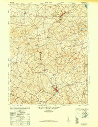
 1944 Hampton1944 Print · USGSAdams County townships like Huntington and Straban appear here during the mid-1940s, showing a landscape of small farms and family-named schools. You can trace old property lines and local landmarks from Round Hill School to the banks of Conewago Creek.5 unique versions available
 - 1945 Map of Bel Air
 1945 Bel Air1945 Print · USGSThe Maryland-Pennsylvania borderlands are captured here at the end of the war, centered on the winding Maryland and Pennsylvania R. R. corridor. Genealogists and historians can trace the early layout of Whiteford, Delta, and Clermont Mills as they appeared in the mid-1940s.
 - 1948 Map of Baltimore
 1948 Baltimore1948 Print · USGSMaryland and Pennsylvania crossroads are captured in the late 1940s, showing a landscape defined by historic rail lines and major military installations. Genealogists can trace family connections in Gettysburg, Westminster, and near the U.S. Naval Academy in Annapolis.2 unique versions available
 - 1948 Map of Belair
 1948 Belair1948 Print · USGSHarford County and southern York County appear at a mid-century crossroads as the post-war era begins. Researchers can trace the winding Maryland and Pennsylvania railroad, find several dozen country churches, and locate industrial relics like the Talc (Abandoned) mine.2 unique versions available
End of results
Showing maps 1-15 of 15
Top cities of York County
- York historical maps
- Hanover historical maps
- West Manheim Township historical maps
- Shrewsbury historical maps
- Red Lion historical maps
- West York historical maps
See more
Frequently asked questions
- What are the different types of historical maps available for York County?
- What is the oldest map of York County?
- Where can I purchase historical maps of York County for my home or office?
- Where can I download high-res historical maps of York County?
- Are there historical topographic maps available for York County?
- Is there historical aerial imagery available for York County?
- Where are historical maps of York County sourced from?