Old Maps of York County, Pennsylvania for Hiking & Exploration
Hike through history with 146 historic maps of York County. Explore old trails, ghost towns, and forgotten backroads — perfect for outdoor adventurers and local explorers.
- Rediscover forgotten places: Map out old mining camps, roads, and footpaths that no longer exist on modern maps.
- Layer with modern tools: Combine with LiDAR or satellite views to plan hikes through historical terrain.
- Made for exploration: Popular among hikers, overlanders, and local history lovers.
Use these maps to find adventure and explore the hidden past of York County.
York County, PA maps
(146)- 1900 Map of Havre De Grace
 1900 Havre De Grace1900 Print · USGSThe Susquehanna River valley at the turn of the century shows a landscape transitioning from the canal era to the railroad age. Genealogists and historians can trace defunct transport routes like the Tidewater Canal alongside active hubs like Rising Sun and Port Deposit.7 unique versions available
 - 1900 Map of Parkton
 1900 Parkton1900 Print · USGSThe Pennsylvania-Maryland borderlands in the early 1900s were defined by the busy Northern Central RR and the many mills along Gunpowder Falls. Researchers can trace old family locales and crossroads like Philopolis, Mount Carmel Ch, and Gorsuchs Mills.
 - 1901 Map of Belair
 1901 Belair1901 Print · USGSThe Harford County borderlands at the start of the twentieth century show a landscape defined by rail corridors and early mining. Genealogists can trace family names and small settlements along the Maryland and Pennsylvania RR, such as Fawn Grove, McIntyre Minefield, and Delta.7 unique versions available
 - 1902 Map of Parkton
 1902 Parkton1902 Print · USGSMaryland and Pennsylvania borders were still defined by active rail and milling economies when this survey was completed. Genealogists can trace family homesteads near Gorsuchs Mills, the Northern Central R.R. corridor, and the historic Maryland Line.7 unique versions available
 - 1904 Map of Carlisle
 1904 Carlisle1904 Print · USGSCumberland County at the opening of the century is a network of thriving rail hubs and rural gaps. Genealogists and historians can trace the foundations of Carlisle, find the grounds of the Carlisle Indian School, and locate rural landmarks like Salem Church and Boiling Springs.7 unique versions available
 - 1905 Map of Westminster
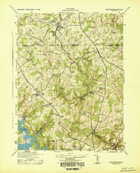
 1905 Westminster1905 Print · USGSCarroll and York Counties come alive in the first decade of the twentieth century as the rail lines connected growing Maryland villages to the Pennsylvania border. Genealogists can trace family roots through historic landmarks like Bethel Ch, Hokes PO, and early milling sites like Bachman Mills.6 unique versions available
 - 1906 Map of New Cumberland
 1906 New Cumberland1906 Print · USGSCentral Pennsylvania at the opening of the twentieth century shows a landscape transitioning from canal-era transit to a heavy rail and industrial economy. Genealogists can locate family landmarks like Shafer Schoolhouse, Salem Church, and the Middletown Ferry.8 unique versions available
 - 1908 Map of Middletown
 1908 Middletown1908 Print · USGSThe Susquehanna River corridor thrives in the early 1900s as a hub for the Pennsylvania Railroad and the burgeoning industry of Lancaster and Dauphin counties. Researchers can trace the path of the Pennsylvania Canal (Abandoned) and locate family-named landmarks like Shocks Mills or Hoffer Church.7 unique versions available
 - 1908 Map of Gettysburg
 1908 Gettysburg1908 Print · USGSGettysburg and rural Adams County appear in the early twentieth century as a landscape of memorialized battlefields and thriving rail-side villages. Genealogists can trace family roots through numerous country schools and landmark mills like Bream Mill or the Bermudian Churches.6 unique versions available
 - 1908 Map of York, 1963 Print
 1908 York1963 Print · USGSYork County's diverse industrial and agricultural landscape is captured here in the early twentieth century. Researchers can trace ancestral property near dozens of local landmarks like Margaretta Furnace, Smalls School, and the Camp Meeting Grounds.
 - 1910 Map of York
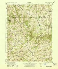
 1910 York1910 Print · USGSYork County at the turn of the century reveals a landscape shaped by rail expansion and deep-rooted rural industry. Genealogists and historians can trace family-named sites like Sechrist Mill, Klein School, and Hopewell Church along the winding Maryland & Pennsylvania RR.6 unique versions available
 - 1912 Map of Mc Calls Ferry
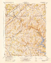
 1912 Mc Calls Ferry1912 Print · USGSThe Susquehanna River valley near Safe Harbor is caught at a peak of rail-and-mill development during this pre-war survey. Genealogists and historians can trace the foundations of Martic Forge, find remote country schools like Red Hill School, and locate old stops on the Pennsylvania RR.5 unique versions available
 - 1920 Map of Hanover, 1959 Print
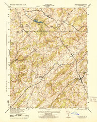
 1920 Hanover1959 Print · USGSYork County's rail-and-mill economy is on full display in the early twentieth century, centered on the busy junctions of Hanover and Hanover Junction. Genealogists and local historians can trace hundreds of rural sites, including Lischy Church, Porters Sideling, and the Trimmer's School.
 - 1922 Map of Hanover
 1922 Hanover1922 Print · USGSYork County's rolling farmland and industrial hubs are captured here in the early 1920s, just as the Lincoln Highway began transforming rural travel. Genealogists can locate family-named landmarks and country institutions like Wildasin Chapel, Menges Mills, and the Iron Ridge Ironore PO.5 unique versions available
 - 1942 Map of Havre De Grace
 1942 Havre De Grace1942 Print · USGSThe Susquehanna riverfront and Mason-Dixon borderlands are captured here in the early 1940s, just as modern infrastructure began to reshape the region. Genealogists can trace family roots through landmarks like Smith Chapel, Lees Mill, and the Brookview Cem near Rising Sun.4 unique versions available
 - 1942 Map of Bel Air
 1942 Bel Air1942 Print · USGSHarford and York counties at the start of the 1940s show a landscape shaped by the Maryland and Pennsylvania R.R. and deep-cut creek valleys. Trace the local rail-and-mill economy through Clermont Mills, Whiteford, and the village of Delta near the state line.
 - 1942 Map of Gettysburg, 1944 Print
 1942 Gettysburg1944 Print · USGSGettysburg and its surrounding borderlands are shown in great detail during the early 1940s, capturing the region's dense network of rural schools and mills. Genealogists can trace family-named landmarks such as Galt Kump PO, Hafers Mill, and Philips Delight Sch.
 - 1943 Map of New Cumberland
 1943 New Cumberland1943 Print · USGSGreater Harrisburg and the lower Susquehanna valley appear here in the midst of the Second World War, showing a landscape of intense military and social transition. Researchers can trace family roots through numerous country landmarks like Eberlys Mill, the Methodist Orphanage, and Messiah Bible College.
 - 1943 Map of Middletown
 1943 Middletown1943 Print · USGSAs World War II mobilization reached its peak, this survey captures the Susquehanna River corridor as a vital industrial and rail artery. Genealogists and researchers can trace family landmarks like Donegal Springs Church, Codorus Furnace, and the early layout of Three Mile Island.
 - 1943 Map of Mc Calls Ferry
 1943 Mc Calls Ferry1943 Print · USGSMid-century Pennsylvania life unfolds along the Susquehanna during the 1940s, where river-based industry and rail lines meet established farming townships. Researchers can trace ancestral locations from Washington Boro to rural landmarks like Erbs Mill, Bethel Church, and the Red Hill School.2 unique versions available
 - 1943 Map of Carlisle, 1944 Print
 1943 Carlisle1944 Print · USGSCumberland County during the mid-forties reveals a landscape transitioning between its deep industrial roots and new high-speed transit. Genealogists and historians can trace family locations through numerous rural landmarks like Farmers Academy, Reading Banks, and the Carlisle Barracks.3 unique versions available
 - 1944 Map of New Freedom
 1944 New Freedom1944 Print · USGSThe Pennsylvania-Maryland border during the mid-forties reveals a rural landscape of tight-knit communities centered on the Pennsylvania Railroad. Genealogists and historians can trace the foundations of local life through the Summit Grove Camp Meeting, Bentley Springs, and the 6th District Consolidated School.
 - 1944 Map of Manchester
 1944 Manchester1944 Print · USGSThe Pennsylvania-Maryland border country was a landscape of mill seats and rural schools in the 1940s. Genealogists and historians can trace the Mason And Dixon Line past Bachman Mills, Hoffackers School, and St Bartholomew Church.
 - 1944 Map of Norrisville
 1944 Norrisville1944 Print · USGSMaryland and Pennsylvania borderlands meet along the Mason and Dixon Line during the mid-1940s. Genealogists and researchers can trace rural life through landmarks like Ivory Mill, Ebaughs School, and the McKendree Church.
 - 1944 Map of Lineboro
 1944 Lineboro1944 Print · USGSMaryland and Pennsylvania border life is captured here in the mid-1940s, centered on the Mason and Dixon Line. Researchers can trace rural genealogy and land use through landmarks like Baughmans Mill, Stiltz, and the Blackrock Chapel & School.
Showing maps 1-25 of 146
Top cities of York County
- York historical maps
- Hanover historical maps
- West Manheim Township historical maps
- Shrewsbury historical maps
- Red Lion historical maps
- West York historical maps
See more
Frequently asked questions
- What are the different types of historical maps available for York County?
- What is the oldest map of York County?
- Where can I purchase historical maps of York County for my home or office?
- Where can I download high-res historical maps of York County?
- Are there historical topographic maps available for York County?
- Is there historical aerial imagery available for York County?
- Where are historical maps of York County sourced from?