1990s Maps of North Codorus Township, Pennsylvania
Explore 5 historic maps of North Codorus Township from the 1990s. These maps offer a rare glimpse into what life looked like during the 1990s — showing old roads, neighborhoods, homes, and landmarks that have changed or disappeared over time.
Whether you're researching your family's past, planning a metal detecting trip, or studying how North Codorus Township's landscape evolved across the 1990s, these high-resolution maps are a powerful tool for exploring the history of this region.
- Focus on a specific era: All maps on this page are from the 1990s, giving you a focused view of this time period.
- See what’s changed: Compare century-old streets, trails, and buildings to today's modern landscape using overlays and satellite layers.
- Research with precision: Use these maps for genealogy, historical research, land use analysis, or educational projects.
- View, download, or print: Maps are fully viewable online in high resolution, and can be downloaded or printed for your own records.
Start exploring North Codorus Township's history through authentic maps from the 1990s. This is your window into the past.
North Codorus Township, PA maps
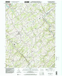
(5)- 1998 Map of Hanover, 2000 Print
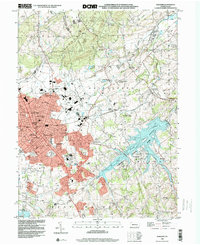 1998 Hanover2000 Print · USGSYork County's southern borderlands near the end of the century reveal a landscape of growing towns and industrial heritage. Genealogists and researchers can trace family landmarks like Mt Olivet Cem, Menges Mills, and several rural schools such as Bears Sch and Zumbrum Sch.
 - 1998 Map of West York, 2000 Print
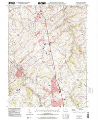
 1998 West York2000 Print · USGSWest York and its surrounding townships show the transition from rural landscape to suburban growth in the late nineties. Genealogists and historians can trace family locations through Strayers Cem, visit old school sites like Boyer Sch, and locate the New Salem (York New Salem PO).
 - 1999 Map of York, 2001 Print
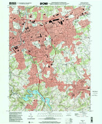 1999 York2001 Print · USGSYork and its surrounding boroughs are captured at the close of the twentieth century, showing a transition from dense urban centers to burgeoning suburban valleys. Trace local history through family landmarks like Reynolds Mill, old burial grounds such as Stump Cem, and the historic Lincoln Highway.
 - 1999 Map of Glen Rock, 2001 Print
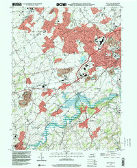
 1999 Glen Rock2001 Print · USGSSouthern York County at the end of the twentieth century shows a landscape of historic boroughs linked by winding creeks and modern interchanges. Genealogists and local historians can trace family sites at Friedensaal Ch Cem, the borough of Glen Rock, and the aptly named village of Railroad.
 - 1999 Map of Seven Valleys, 2002 Print
 1999 Seven Valleys2002 Print · USGSSouthern York County's rail-and-creek valleys come alive in this map from the late twentieth century. Genealogists and local historians can trace family roots through old rural crossroads and landmarks like Hanover Junction, Seitzville, and the Zion Shaeffer Union Ch.
End of results
Showing maps 1-5 of 5
Top cities near North Codorus Township
- York historical maps
- Hanover historical maps
- Parkville historical maps
- West Manheim Township historical maps
- Shrewsbury historical maps
- Hampstead historical maps
See more
Top neighborhoods of North Codorus Township
- Cold Spring historical maps
- Ambau historical maps
- Hanover Junction historical maps
- Stoverstown historical maps
- Strickhousers historical maps
- Lehman historical maps
Frequently asked questions
- What are the different types of historical maps available for North Codorus Township?
- What is the oldest map of North Codorus Township?
- Where can I purchase historical maps of North Codorus Township for my home or office?
- Where can I download high-res historical maps of North Codorus Township?
- Are there historical topographic maps available for North Codorus Township?
- Is there historical aerial imagery available for North Codorus Township?
- Where are historical maps of North Codorus Township sourced from?