1900-1909 Maps of Rhode Island
Explore 4 historic maps of Rhode Island from 1900-1909. These maps offer a rare glimpse into what life looked like during the 1900s — showing old roads, neighborhoods, homes, and landmarks that have changed or disappeared over time.
Whether you're researching your family's past, planning a metal detecting trip, or studying how Rhode Island's landscape evolved across the 1900s, these high-resolution maps are a powerful tool for exploring the history of this region.
- Focus on a specific era: All maps on this page are from the 1900s, giving you a focused view of this time period.
- See what’s changed: Compare century-old streets, trails, and buildings to today's modern landscape using overlays and satellite layers.
- Research with precision: Use these maps for genealogy, historical research, land use analysis, or educational projects.
- View, download, or print: Maps are fully viewable online in high resolution, and can be downloaded or printed for your own records.
Start exploring Rhode Island's history through authentic maps from the 1900s. This is your window into the past.
Rhode Island maps
(4)- 1900 Map of Blackstone
 1900 Blackstone1900 Print · USGSThe Blackstone Valley was a bustling manufacturing corridor when this late Victorian-era survey was published. Genealogists and historians can trace the industrial mill villages along the Blackstone River, including Whitinsville, Manchaug, and Millville.7 unique versions available
 - 1904 Map of Montauk
 1904 Montauk1904 Print · USGSThe tip of Long Island at the turn of the century is a maritime frontier where the railway meets the Atlantic. Researchers can trace the early layout of Montauk, the vital Montauk Point L.H., and coastal life-saving stations like Ditch Plain L.S.S.6 unique versions available
 - 1904 Map of Newport, 1912 Print
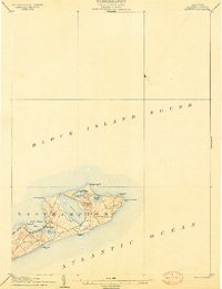
 1904 Newport1912 Print · USGSCoastal Rhode Island thrived at the dawn of the century, with its bustling harbors and strategic military outposts guarding the bay. Trace the early streets of Newport, the defenses at Fort Adams, and the waterfront at Narragansett Pier.
 - 1908 Map of Quinsigamond
 1908 Quinsigamond1908 Print · USGSCentral Massachusetts and its bordering states are seen here in the early twentieth century as industry and transit reshaped the Blackstone Valley. Genealogists and historians can trace the early footprints of Worcester, the expansion of the Wachusett Reservoir, and rail lines like the Boston and Albany Railroad.3 unique versions available
End of results
Showing maps 1-4 of 4
Top cities of Rhode Island
- Providence historical maps
- Warwick historical maps
- Cranston historical maps
- Pawtucket historical maps
- East Providence historical maps
- Woonsocket historical maps
See more
Top counties of Rhode Island
- Providence County historical maps
- Kent County historical maps
- South County historical maps
- Newport County historical maps
- Bristol County historical maps
Frequently asked questions
- What are the different types of historical maps available for Rhode Island?
- What is the oldest map of Rhode Island?
- Where can I purchase historical maps of Rhode Island for my home or office?
- Where can I download high-res historical maps of Rhode Island?
- Are there historical topographic maps available for Rhode Island?
- Is there historical aerial imagery available for Rhode Island?
- Where are historical maps of Rhode Island sourced from?