1960s Maps of Rhode Island
Explore 11 historic maps of Rhode Island from the 1960s. These maps offer a rare glimpse into what life looked like during the 1960s — showing old roads, neighborhoods, homes, and landmarks that have changed or disappeared over time.
Whether you're researching your family's past, planning a metal detecting trip, or studying how Rhode Island's landscape evolved across the 1960s, these high-resolution maps are a powerful tool for exploring the history of this region.
- Focus on a specific era: All maps on this page are from the 1960s, giving you a focused view of this time period.
- See what’s changed: Compare century-old streets, trails, and buildings to today's modern landscape using overlays and satellite layers.
- Research with precision: Use these maps for genealogy, historical research, land use analysis, or educational projects.
- View, download, or print: Maps are fully viewable online in high resolution, and can be downloaded or printed for your own records.
Start exploring Rhode Island's history through authentic maps from the 1960s. This is your window into the past.
Rhode Island maps
(11)- 1961 Map of Boston
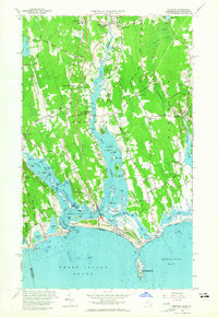
 1961 Boston1961 Print · USGSThe Massachusetts coastline and its industrial interior are detailed here in the mid-twentieth century, from the Monadnock highlands to Cape Cod. Researchers can trace the rail routes of the Boston and Maine or locate landmarks like Fort Devens and the Wachusett Reservoir.2 unique versions available
 - 1963 Map of Providence
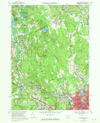
 1963 Providence1963 Print · USGSSouthern New England's coastal and industrial heartland is captured here in the early sixties, from the Rhode Island mainland to the far reaches of the Cape. Researchers can trace mid-century growth in Providence or locate landmarks on Marthas Vineyard and Nantucket Island.
 - 1963 Map of Westport, 1965 Print
 1963 Westport1965 Print · USGSThe Westport and Dartmouth coastlines come alive in the early sixties, showing a landscape of tidal flats and colonial crossroads. Genealogists and historians can trace family-named landmarks like Kirby Corner and Snell Corner, or locate the New Bedford City Rifle Range.3 unique versions available
 - 1964 Map of Oxford
 1964 Oxford1964 Print · USGSThe tri-state border region of Massachusetts, Connecticut, and Rhode Island comes alive in this mid-century survey. Genealogists and researchers can map family plots at St Joseph Cem or trace the winding shores of Lake Chaubunagungamaug.
 - 1964 Map of Franklin, 1965 Print
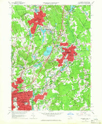
 1964 Franklin1965 Print · USGSThe borderlands of Massachusetts and Rhode Island are shown in the mid-1960s as suburban growth met traditional industry. Trace family sites like Ballou Cem, find old neighborhood names like Sheldonville, or locate the Dean Jr College campus.4 unique versions available
 - 1964 Map of Attleboro, 1966 Print
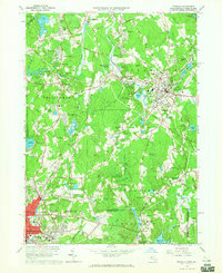
 1964 Attleboro1966 Print · USGSThe Attleboro area and the Rhode Island borderlands are shown here in the mid-1960s, a period of established industrial and institutional growth. Genealogists can trace family sites at Mount Hope Cem or North Purchase Cem, and explore schools like Bishop Feehan High Sch.4 unique versions available
 - 1965 Map of Franklin, 1979 Print
 1965 Franklin1979 Print · USGSThe Massachusetts and Rhode Island border country comes into focus in the mid-twentieth century, showing the growing suburbs around Bellingham and Unionville. Genealogists and historians can trace family plots at Ballou Cem and locate institutional landmarks like Dean Junior College and St Marys Abbey.
 - 1967 Map of Fall River, 1970 Print
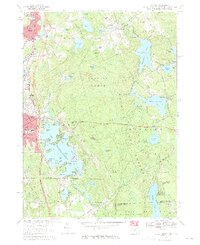
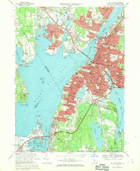 1967 Fall River1970 Print · USGSFall River and the surrounding Narragansett Bay communities are captured here in the late sixties during a period of significant suburban and highway growth. Researchers can trace family roots through the dense city blocks of Globe Village or locate ancestral sites at Oak Grove Cemetery and North Burial Ground.5 unique versions available
 - 1969 Map of Blackstone, 1971 Print
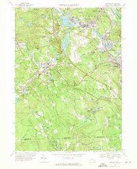
 1969 Blackstone1971 Print · USGSThe Blackstone River valley comes alive in the late sixties, showing the industrial heart of the Massachusetts and Rhode Island border. Researchers can trace ancestral roots through dozens of local sites, from the Chestnut Hill Meeting House Cem to the storied streets of Woonsocket and Millville.6 unique versions available
 - 1969 Map of Oxford, 1971 Print
 1969 Oxford1971 Print · USGSThe tri-state border region of Massachusetts, Connecticut, and Rhode Island is captured here in the late sixties, showcasing its industrial villages and extensive pond systems. Researchers can locate St Josephs Cemetery, trace the Penn Central line, or explore the shores of Lake Chaubunagungamaug.4 unique versions available
 - 1969 Map of Uxbridge, 1971 Print
 1969 Uxbridge1971 Print · USGSThe Blackstone Valley industrial corridor is captured here in the late sixties, showing the well-established mill towns of Massachusetts and Rhode Island. Researchers can locate family sites and landmarks like Evergreen Cem, East Douglas Station, and the Halfway House.4 unique versions available
End of results
Showing maps 1-11 of 11
Top cities of Rhode Island
- Providence historical maps
- Warwick historical maps
- Cranston historical maps
- Pawtucket historical maps
- East Providence historical maps
- Woonsocket historical maps
See more
Top counties of Rhode Island
- Providence County historical maps
- Kent County historical maps
- South County historical maps
- Newport County historical maps
- Bristol County historical maps
Frequently asked questions
- What are the different types of historical maps available for Rhode Island?
- What is the oldest map of Rhode Island?
- Where can I purchase historical maps of Rhode Island for my home or office?
- Where can I download high-res historical maps of Rhode Island?
- Are there historical topographic maps available for Rhode Island?
- Is there historical aerial imagery available for Rhode Island?
- Where are historical maps of Rhode Island sourced from?