Old Maps of North Kingstown, Rhode Island
Explore 71 old maps of North Kingstown, spanning from 1889 to today. These high-resolution historic maps reveal how streets, neighborhoods, landmarks, and natural features evolved over time — perfect for genealogy, metal detecting, research, and local history exploration.
What you can do with these maps:
- See how North Kingstown changed over time: Compare historical maps to modern-day views to trace roads, homesites, rail lines & more.
- View detailed metadata: Each map includes creators, publishers, year, scale, and archive source.
- Overlay maps with satellite & LiDAR: Visualize the past alongside modern tools to explore terrain & human change.
- Trusted historical sources: Maps sourced from the USGS, Library of Congress, and other archives.
- Access maps your way: View online, download high-res files, or order prints for personal or research use.
Start exploring old maps of North Kingstown to uncover forgotten places, hidden landmarks, and the deep history beneath your feet.
North Kingstown, RI maps
(71)- 1889 Map of Charlestown
 1889 Charlestown1889 Print · USGSCoastal Washington County in the late Victorian era is defined by salt ponds and a burgeoning rail network. Genealogists and historians can trace the early layouts of Quonochontaug, Carolina, and Richmond Switch near landmarks like Indian Burying Hill.9 unique versions available
 - 1889 Map of Newport
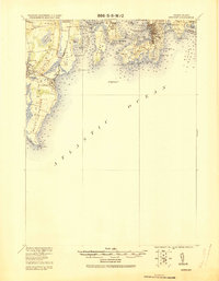
 1889 Newport1889 Print · USGSNewport and the surrounding Narragansett Bay area are captured in the late 1880s, showcasing a landscape of coastal fortifications and maritime commerce. Local historians can trace the foundations of Narragansett Pier, the busy harbor at Fort Adams, and vanished landmarks like Watsons Pier.
 - 1890 Map of Narragansett Bay
 1890 Narragansett Bay1890 Print · USGSNarragansett Bay's western shore comes to life in the late nineteenth century, showing a landscape of rail-linked villages and coastal landmarks. Genealogists and historians can trace old homesteads and transit hubs from Wickford Junction to the State Farm and the Bristol Ferry.
 - 1890 Map of Kent
 1890 Kent1890 Print · USGSRhode Island's industrial heartland is in full swing during the late nineteenth century, dominated by mill towns and busy rail lines. Trace the development of Phenix, Coventry Center, and Arctic along the Pawtuxet River and the expanding New York and New England Railroad.
 - 1892 Map of Narragansett Bay
 1892 Narragansett Bay1892 Print · USGSNarragansett Bay in the late nineteenth century reveals a coastline defined by maritime commerce and early rail connectivity. Genealogists can trace family roots in old village centers like Wickford, Apponaug, and Conimicut, or locate the State Prison near Natick.8 unique versions available
 - 1894 Map of Kent
 1894 Kent1894 Print · USGSCentral Rhode Island’s mill towns and rural uplands are shown here at the height of the Victorian era. Researchers can trace the path of the Valley Railroad through industrial hubs like Phenix or locate small settlements like Noose Neck and Usquepaug.7 unique versions available
 - 1894 Map of Newport
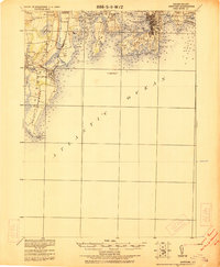
 1894 Newport1894 Print · USGSCoastal Rhode Island was a hive of maritime activity and late-Victorian growth when this survey was conducted. Researchers can trace the legacy of Narragansett Bay through landmarks like Fort Adams, the Narragansett Pier R.R., and Beaver Tail Light.3 unique versions available
 - 1904 Map of Newport, 1912 Print
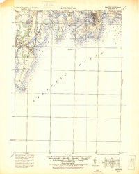
 1904 Newport1912 Print · USGSCoastal Rhode Island thrived at the dawn of the century, with its bustling harbors and strategic military outposts guarding the bay. Trace the early streets of Newport, the defenses at Fort Adams, and the waterfront at Narragansett Pier.
 - 1919 Map of Charlestown
 1919 Charlestown1919 Print · USGSCoastal Rhode Island just after the Great War shows a landscape of rail-connected mill villages and sprawling salt ponds. Researchers can trace the legacy of the R.I. Agricultural College or locate landmarks like the King Philip Monument and Indian Burying Hill.
 - 1919 Map of Narragansett Bay, 1921 Print
 1919 Narragansett Bay1921 Print · USGSThe Rhode Island coast thrived as a hub of rail and maritime activity during the early twentieth century. Genealogists and historians can trace rail lines like the Sea View Electric R.R. and locate old landmarks like the Portsmouth Coal Mines and State Farm.2 unique versions available
 - 1920 Map of Newport
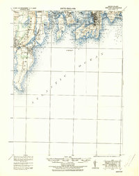
 1920 Newport1920 Print · USGSNarragansett Bay at the end of the Great War reveals a landscape defined by coastal defense and maritime trade. Trace the lines of the Sea View R.R. Co. Electric R.R. or locate historic military sites like Fort Kearney and Fort Adams.2 unique versions available
 - 1921 Map of Charlestown
 1921 Charlestown1921 Print · USGSThe Rhode Island coastline near Charlestown is shown in the early twentieth century before modern development altered the barrier beaches. Trace family history through the inland rail junctions and schools like R.I. Agricultural College and Wood River Junction.
 - 1922 Map of Newport
 1922 Newport1922 Print · USGSThe Rhode Island coast after the turn of the century shows a landscape of strategic forts and bustling seaside resorts. Trace the path of the Sea View R.R. Co. Electric or locate historic military sites like Fort Adams and Fort Kearney.
 - 1931 Map of Newport
 1931 Newport1931 Print · USGSCoastal Rhode Island just after the Great War shows a landscape of strategic forts and bustling summer colonies. Genealogists and historians can trace the early Sea View R.R. through Narragansett Pier or locate family estates near Ochre Point.
 - 1935 Map of Newport
 1935 Newport1935 Print · USGSNarragansett Bay's military and maritime character is on full display in the mid-1930s. Researchers can trace the Sea View R.R. Co. Electric R.R. or locate coastal fortifications like Fort Adams and Fort Kearney.
 - 1942 Map of Newport
 1942 Newport1942 Print · USGSThe Rhode Island coast appears here at a critical wartime moment, showing the heavy fortification of Narragansett Bay. Researchers can trace military sites like Fort Kearny, maritime landmarks like the Point Judith Life Saving Station, and old ferry routes.2 unique versions available
 - 1942 Map of Block Island, 1943 Print
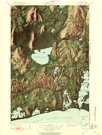
 1942 Block Island1943 Print · USGSThe coastal borderlands of Rhode Island and Connecticut are captured here during the wartime years, documenting a landscape defined by rail and sea. Researchers can trace the NY NH & H RR through historic mill villages or locate landmarks like the Silex Mine and Indian Burying Hill.2 unique versions available
 - 1942 Map of Kingston, 1953 Print
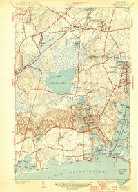
 1942 Kingston1953 Print · USGSSouthern Rhode Island at the onset of the 1940s reveals a landscape of quiet academic towns, massive freshwater swamps, and busy salt-pond harbors. Genealogists and historians can trace family locations near the Great Swamp Fight Site, St Francis Cem, and the old campus of Rhode Island State College.4 unique versions available
 - 1942 Map of Wickford, 1957 Print
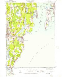
 1942 Wickford1957 Print · USGSWickford and the West Passage are captured here just as modern transit began to reshape the coastline. Genealogists can trace family names at Quidnessett Cem and Allenton Cem or locate homes near Wickford Junction and Hamilton.
 - 1942 Map of Narragansett Pier, 1957 Print
 1942 Narragansett Pier1957 Print · USGSCoastal Rhode Island is captured here in the early 1940s, showing the intersection of resort life and maritime defense. Researchers can trace local landmarks from Narragansett Pier to the tactical grounds of Fort Nathaniel Green and Fort Phillip Kearney.
 - 1942 Map of East Greenwich, 1958 Print
 1942 East Greenwich1958 Print · USGSThe Rhode Island coast south of Cranston was a hub of institutional life and maritime activity in the early 1940s. Genealogists and historians can trace the foundations of Apponaug, the grounds of the State Farm, or locate the St Marys Ch and Oakland Beach Sch.
 - 1943 Map of Providence
 1943 Providence1943 Print · USGSNarragansett Bay and the industrial Blackstone Valley appear here in the midst of the Second World War. Genealogists and researchers can trace local landmarks like Lonsdale Station, the St Marys Reservoir, and the Rhode Island State Airport.
 - 1943 Map of Slocum
 1943 Slocum1943 Print · USGSRhode Island's rural interior comes into focus during the early 1940s, showing a landscape of upland farms, mill ponds, and dispersed hamlets. Researchers can locate vanished schoolhouses and local landmarks like Hitty Corner Sch, Yorker Mill Pond, and the State Hospital.2 unique versions available
 - 1943 Map of Putnam, 1944 Print
 1943 Putnam1944 Print · USGSThe Connecticut and Rhode Island borderlands are captured here during the wartime era, showing a landscape defined by textile river towns and sprawling state forests. Trace the industrial rail corridor of the New York New Haven and Hartford through Putnam, Danielson, and Moosup.
 - 1944 Map of Kingston
 1944 Kingston1944 Print · USGSSouth Kingstown and the surrounding coastal villages are shown here during the early years of the Second World War. Genealogists and researchers can trace family landmarks and early civic life at Rhode Island State College, the Matunuck Sch, and the Great Swamp Fight Site.2 unique versions available
Showing maps 1-25 of 71
Top cities near North Kingstown
- Providence historical maps
- Warwick historical maps
- Cranston historical maps
- East Providence historical maps
- Coventry historical maps
- West Warwick historical maps
See more
Top neighborhoods of North Kingstown
- Davisville historical maps
- Wickford historical maps
- Saunderstown historical maps
- Slocum historical maps
- Annaquatucket historical maps
- Belleville historical maps
See more
Frequently asked questions
- What are the different types of historical maps available for North Kingstown?
- What is the oldest map of North Kingstown?
- Where can I purchase historical maps of North Kingstown for my home or office?
- Where can I download high-res historical maps of North Kingstown?
- Are there historical topographic maps available for North Kingstown?
- Is there historical aerial imagery available for North Kingstown?
- Where are historical maps of North Kingstown sourced from?