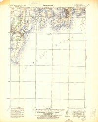
1931 Map of Newport
USGS Topo · Published 1931About this map
Coastal defenses and maritime infrastructure define the entrance to Narragansett Bay in this 1931 edition, which incorporates military survey data from the early twentieth century. The tactical importance of the harbor is evident through the concentration of installations such as Fort Adams, Fort Wetherill, and the Naval Torpedo Sta. on Goat Island. On the western shore, the Sea View R.R. Co. Electric R.R. connects the settlements of Wakefield and Narragansett Pier, tracing the coast toward Point Judith.
Find a feature on this map
78 named features on this map. Tap any name to fly to it.
Don’t see what you’re looking for? This feature index may not catch every label — zoom into the map to look around manually.
Map Details
Editions of this 1931 Newport Map
This is the sole edition of this map. No revisions or reprints were ever made.
Other maps of this area

1885 · Sakonnet
USGS Topo · 1:62,500

1888 · Fall River
USGS Topo · 1:62,500

1888 · Sakonnet
USGS Topo · 1:62,500

1889 · Charlestown
USGS Topo · 1:62,500

1889 · Newport
USGS Topo · 1:62,500

1889 · Block Island
USGS Topo · 1:62,500

1890 · Narragansett Bay
USGS Topo · 1:62,500

1890 · Kent
USGS Topo · 1:62,500

1892 · Narragansett Bay
USGS Topo · 1:62,500

1893 · Sakonnet
USGS Topo · 1:62,500