Old Maps of Foster, Rhode Island for Metal Detecting
Plan your next treasure hunt with 52 historic maps of Foster. Find old homesites, ghost towns, trails, and gathering spots that may be lost to time — perfect for identifying promising metal detecting locations.
- Locate forgotten sites: Uncover places like long-lost settlements, abandoned rail lines, or gathering spots.
- Plan better hunts: Use map overlays combined with LiDAR or satellite views to narrow in on historically rich areas.
- Made for detectorists: Thousands of hobbyists use these maps to discover relics, coins, and hidden history.
Use these historic maps to boost your research and find new opportunities beneath the surface of Foster.
Foster, RI maps
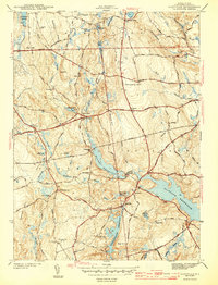
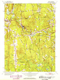
(52)- 1889 Map of Putnam
 1889 Putnam1889 Print · USGSThe industrial Quinebaug Valley comes alive in the late 1880s, showcasing a landscape of riverside mill towns and critical rail junctions. Genealogists can trace family roots through specific locales like Danielsonville, Putnam Heights P.O., and Thompson Station.
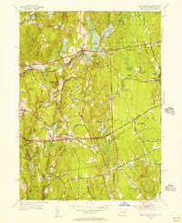
 - 1889 Map of Burrillville
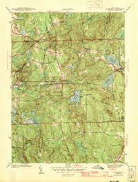
 1889 Burrillville1889 Print · USGSNorthwest Rhode Island at the peak of the industrial era shows a landscape of busy mill villages and vital rail corridors. Genealogists and historians can trace the foundations of local industry and transport at Harrisville, Tarkiln Station, and Slatersville.
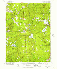
 - 1889 Map of Moosup
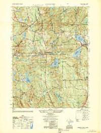
 1889 Moosup1889 Print · USGSThe Connecticut-Rhode Island borderlands were a hive of rail activity and river power in the late nineteenth century. You can trace early transit routes through Plainfield Junction or locate rural landmarks like Moosup Valley P.O. and Sterling Station.
 - 1890 Map of Kent
 1890 Kent1890 Print · USGSRhode Island's industrial heartland is in full swing during the late nineteenth century, dominated by mill towns and busy rail lines. Trace the development of Phenix, Coventry Center, and Arctic along the Pawtuxet River and the expanding New York and New England Railroad.
 - 1893 Map of Putnam
 1893 Putnam1893 Print · USGSNortheastern Connecticut and the Rhode Island borderlands are documented here in the 1890s as the rail-and-river economy reached its peak. Researchers can trace historic mill villages like Ballouville, follow the New York and New England Railroad, or locate family sites near Danielsonville.8 unique versions available
 - 1893 Map of Moosup
 1893 Moosup1893 Print · USGSEastern Connecticut and western Rhode Island meet here in the late nineteenth century at a peak of rail-driven industry. Genealogists can trace family footprints through historic hubs like Jewett City, Hopkins Hollow, and the mills surrounding Pachaug Pond.7 unique versions available
 - 1894 Map of Burrillville
 1894 Burrillville1894 Print · USGSNorthwest Rhode Island at the peak of the water-powered textile era reveals a dense network of mill villages and reservoirs. Researchers can trace the path of the Providence and Springfield R. R. and locate family landmarks from Chepachet to Slatersville.6 unique versions available
 - 1894 Map of Kent
 1894 Kent1894 Print · USGSCentral Rhode Island’s mill towns and rural uplands are shown here at the height of the Victorian era. Researchers can trace the path of the Valley Railroad through industrial hubs like Phenix or locate small settlements like Noose Neck and Usquepaug.7 unique versions available
 - 1915 Map of Burrillville
 1915 Burrillville1915 Print · USGSNorthwest Rhode Island at the start of the Great War era reveals a landscape of industrial mill villages and extensive reservoir systems. Trace the early road networks and water-powered settlements of Pascoag, Chepachet, and Georgiaville across the Blackstone Valley hills.
 - 1919 Map of Putnam
 1919 Putnam1919 Print · USGSWindham County and the Rhode Island borderlands are captured here during a period of heavy rail reliance and mill town growth. Researchers can trace the New York and New England Railroad through Pomfret Station or locate local landmarks like Cooke Store and Poutis Landing.
 - 1920 Map of Moosup
 1920 Moosup1920 Print · USGSEastern Connecticut and the Rhode Island border were thriving hubs of textile milling and rail transit just after the Great War. Genealogists and local historians can trace family-named locations such as Hopkins Hollow, industrial sites like Sterling Station, and the intricate rail network at Plainfield Junction.
 - 1921 Map of Burrillville
 1921 Burrillville1921 Print · USGSProvidence County’s mill towns and upland farms are frozen in time just after the Great War, documenting a landscape shaped by water power. Genealogists and historians can trace family-named heights like Chopmist Hill and locate early mill sites in Harrisville, Slatersville, or Pascoag.
 - 1943 Map of Clayville
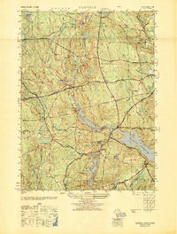
 1943 Clayville1943 Print · USGSThe rural uplands of Providence County are shown during the mid-forties, characterized by a complex network of reservoirs and historic crossroads. Researchers can trace ancestral sites at the Stone Plot, New Rockland Cem, and the old Ponaganset Sch near South Foster.4 unique versions available
 - 1943 Map of Coventry
 1943 Coventry1943 Print · USGSKent County at the height of the war years reveals a landscape of upland forests and tightly-knit crossroads settlements. Genealogists and historians can trace family-named sites like Bowen Hill, rural schools such as Louttit Sch, and early infrastructure including the Airway Beacon.3 unique versions available
 - 1943 Map of Putnam, 1944 Print
 1943 Putnam1944 Print · USGSThe Connecticut and Rhode Island borderlands are captured here during the wartime era, showing a landscape defined by textile river towns and sprawling state forests. Trace the industrial rail corridor of the New York New Haven and Hartford through Putnam, Danielson, and Moosup.
 - 1944 Map of Oneco
 1944 Oneco1944 Print · USGSThe Connecticut and Rhode Island borderlands are captured here during the mid-1940s, showing the rural communities of Windham and Kent counties. Genealogists and local historians can trace family roots at Gallup Cem or locate old schoolhouses and parishes like Sterling Hill Sch and Ekonk Ch.2 unique versions available
 - 1945 Map of East Killingly
 1945 East Killingly1945 Print · USGSThe Connecticut and Rhode Island borderlands are captured here in the mid-1940s, showing a landscape of textile-era reservoirs and upland farms. Researchers can trace historic family burial grounds like Fiske Cem and Paine Cem or locate long-standing rural schoolhouses such as the Mt Hygeia Sch.2 unique versions available
 - 1947 Map of Providence, 1948 Print
 1947 Providence1948 Print · USGSSouthern New England is captured in the mid-1940s, showing a landscape defined by busy industrial ports and expanding military installations. Researchers can trace the rail lines of the N.Y. N.H. & H. RR or locate coastal defenses like Fort Adams and Quonset Point.5 unique versions available
 - 1948 Map of Clayville, 1949 Print
 1948 Clayville1949 Print · USGSProvidence County’s western uplands appear here in the late forties, showing a landscape shaped by significant reservoirs and historical turnpikes. Researchers can locate numerous family burial sites like Wilder Cem and Spear Cem or trace the old roads through South Foster and Foster Center.
 - 1948 Map of Providence, 1951 Print
 1948 Providence1951 Print · USGSSouthern New England’s coastal reaches are captured here in the late 1940s, from the industrial heart of Providence to the tip of Provincetown. Genealogists and historians can trace rail lines like the Central Vermont Railway and locate active military sites such as Otis Air Force Base and Fort Rodman.
 - 1950 Map of East Killingly
 1950 East Killingly1950 Print · USGSThe Connecticut and Rhode Island borderlands are captured here during the 1940s, showing a landscape of upland ridges and industrial brooks. You can trace early schoolhouse locations like Titus Sch and remote burial grounds including Hopkins Cem and Fiske Cem.
 - 1950 Map of Coventry
 1950 Coventry1950 Print · USGSWestern Rhode Island at mid-century reveals a landscape of isolated farmsteads and vital rail connections centered on the town of Coventry. Genealogists and local historians can trace family-named landmarks like Bowen Hill or locate rural landmarks such as Mt Vernon Ch and Summit Sch.
 - 1953 Map of Oneco, 1954 Print
 1953 Oneco1954 Print · USGSThe borderlands of Connecticut and Rhode Island are shown in the early fifties as the railroad still connected industrial hamlets. Genealogists can locate Ekonk Ch, Moosup Valley Cem, and the small airfield at Ricinn Airport.6 unique versions available
 - 1955 Map of East Killingly, 1956 Print
 1955 East Killingly1956 Print · USGSThe Connecticut and Rhode Island borderlands are captured here in the mid-1950s, showing a landscape of textile-era mill towns and upland farms. Trace old property lines and rural communities near East Killingly, the North Foster Ch, and the heights of Jerimoth Hill.6 unique versions available
 - 1955 Map of Coventry Center, 1957 Print
 1955 Coventry Center1957 Print · USGSWestern Rhode Island's rural landscape is captured here in the mid-1950s, showing a region defined by river reservoirs and small rail-stop villages. Researchers can trace family-named hills and old landmarks like Mt Vernon Ch, Kitts Corner, and the Jackson Quarry.5 unique versions available
Showing maps 1-25 of 52
Top cities near Foster
- Warwick historical maps
- Cranston historical maps
- Woonsocket historical maps
- Coventry historical maps
- West Warwick historical maps
- Johnston historical maps
See more
Top neighborhoods of Foster
- South Foster historical maps
- North Foster historical maps
- Hopkins Mills historical maps
- Simmons Corner historical maps
- Moosup Valley historical maps
Frequently asked questions
- What are the different types of historical maps available for Foster?
- What is the oldest map of Foster?
- Where can I purchase historical maps of Foster for my home or office?
- Where can I download high-res historical maps of Foster?
- Are there historical topographic maps available for Foster?
- Is there historical aerial imagery available for Foster?
- Where are historical maps of Foster sourced from?