Old Maps of South County, Rhode Island for Academic Research
Study the evolution of South County with 156 high-resolution historic maps. Whether you're teaching, researching, or modeling changes in land use, these maps provide essential visual documentation of urban, environmental, and geographic change.
- Analyze long-term change: Track patterns in development, transportation, and natural features.
- Ideal for environmental or urban studies: Support academic projects with primary historical map data.
- Use in the classroom or lab: Educators and researchers rely on these maps to bring historical context to life.
These maps are a powerful tool for teaching, research, and visualizing how South County has changed over the decades.
South County, RI maps
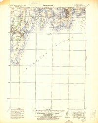
(156)- 1889 Map of Stonington
 1889 Stonington1889 Print · USGSThe Connecticut and Rhode Island borderlands are documented here at the height of the maritime and rail era. Genealogists and historians can trace family-named hills like Stewart Hill or locate industrial sites such as the Silax Mine and the rail hub at Mystic Bridge.
 - 1889 Map of Charlestown
 1889 Charlestown1889 Print · USGSCoastal Washington County in the late Victorian era is defined by salt ponds and a burgeoning rail network. Genealogists and historians can trace the early layouts of Quonochontaug, Carolina, and Richmond Switch near landmarks like Indian Burying Hill.9 unique versions available
 - 1889 Map of Newport
 1889 Newport1889 Print · USGSNewport and the surrounding Narragansett Bay area are captured in the late 1880s, showcasing a landscape of coastal fortifications and maritime commerce. Local historians can trace the foundations of Narragansett Pier, the busy harbor at Fort Adams, and vanished landmarks like Watsons Pier.
 - 1889 Map of Block Island
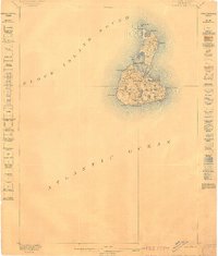
 1889 Block Island1889 Print · USGSRhode Island's offshore landscapes are documented here in the late nineteenth century, showing the island's maritime reliance and isolated settlements. Trace early navigation aids and coastal safety at the Block Island N.L.H. and various L.S. Station locations around New Shoreham.
 - 1889 Map of Moosup
 1889 Moosup1889 Print · USGSThe Connecticut-Rhode Island borderlands were a hive of rail activity and river power in the late nineteenth century. You can trace early transit routes through Plainfield Junction or locate rural landmarks like Moosup Valley P.O. and Sterling Station.
 - 1890 Map of Narragansett Bay
 1890 Narragansett Bay1890 Print · USGSNarragansett Bay's western shore comes to life in the late nineteenth century, showing a landscape of rail-linked villages and coastal landmarks. Genealogists and historians can trace old homesteads and transit hubs from Wickford Junction to the State Farm and the Bristol Ferry.
 - 1890 Map of Kent
 1890 Kent1890 Print · USGSRhode Island's industrial heartland is in full swing during the late nineteenth century, dominated by mill towns and busy rail lines. Trace the development of Phenix, Coventry Center, and Arctic along the Pawtuxet River and the expanding New York and New England Railroad.
 - 1892 Map of Narragansett Bay
 1892 Narragansett Bay1892 Print · USGSNarragansett Bay in the late nineteenth century reveals a coastline defined by maritime commerce and early rail connectivity. Genealogists can trace family roots in old village centers like Wickford, Apponaug, and Conimicut, or locate the State Prison near Natick.8 unique versions available
 - 1893 Map of Moosup
 1893 Moosup1893 Print · USGSEastern Connecticut and western Rhode Island meet here in the late nineteenth century at a peak of rail-driven industry. Genealogists can trace family footprints through historic hubs like Jewett City, Hopkins Hollow, and the mills surrounding Pachaug Pond.7 unique versions available
 - 1893 Map of Stonington
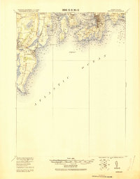
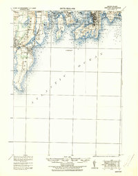
 1893 Stonington1893 Print · USGSThe coastal borderlands of Connecticut and Rhode Island are captured here in the late nineteenth century, showing a landscape defined by maritime trade and river power. Genealogists can trace family landmarks like Ayer Hill and Pequot Hill or locate industrial sites such as the Silex Mine.10 unique versions available
 - 1894 Map of Block Island
 1894 Block Island1894 Print · USGSNew Shoreham's isolated maritime landscape comes alive in this late nineteenth-century survey of the Atlantic's crossroads. Genealogists and historians can locate early coastal infrastructure at the Block Island N.L.H. and the vanished footpaths near New Shoreham Center.
 - 1894 Map of Kent
 1894 Kent1894 Print · USGSCentral Rhode Island’s mill towns and rural uplands are shown here at the height of the Victorian era. Researchers can trace the path of the Valley Railroad through industrial hubs like Phenix or locate small settlements like Noose Neck and Usquepaug.7 unique versions available
 - 1894 Map of Newport
 1894 Newport1894 Print · USGSCoastal Rhode Island was a hive of maritime activity and late-Victorian growth when this survey was conducted. Researchers can trace the legacy of Narragansett Bay through landmarks like Fort Adams, the Narragansett Pier R.R., and Beaver Tail Light.3 unique versions available
 - 1899 Map of Block Island
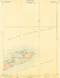
 1899 Block Island1899 Print · USGSRhode Island's offshore gem is captured at the close of the nineteenth century, showing the town of New Shoreham and its critical maritime infrastructure. Genealogists and maritime historians can trace the positions of the Block Island N.L.H., Beacon Hill, and Great Salt Pond.5 unique versions available
 - 1904 Map of Montauk
 1904 Montauk1904 Print · USGSThe tip of Long Island at the turn of the century is a maritime frontier where the railway meets the Atlantic. Researchers can trace the early layout of Montauk, the vital Montauk Point L.H., and coastal life-saving stations like Ditch Plain L.S.S.6 unique versions available
 - 1904 Map of Newport, 1912 Print
 1904 Newport1912 Print · USGSCoastal Rhode Island thrived at the dawn of the century, with its bustling harbors and strategic military outposts guarding the bay. Trace the early streets of Newport, the defenses at Fort Adams, and the waterfront at Narragansett Pier.
 - 1919 Map of Charlestown
 1919 Charlestown1919 Print · USGSCoastal Rhode Island just after the Great War shows a landscape of rail-connected mill villages and sprawling salt ponds. Researchers can trace the legacy of the R.I. Agricultural College or locate landmarks like the King Philip Monument and Indian Burying Hill.
 - 1919 Map of Narragansett Bay, 1921 Print
 1919 Narragansett Bay1921 Print · USGSThe Rhode Island coast thrived as a hub of rail and maritime activity during the early twentieth century. Genealogists and historians can trace rail lines like the Sea View Electric R.R. and locate old landmarks like the Portsmouth Coal Mines and State Farm.2 unique versions available
 - 1920 Map of Moosup
 1920 Moosup1920 Print · USGSEastern Connecticut and the Rhode Island border were thriving hubs of textile milling and rail transit just after the Great War. Genealogists and local historians can trace family-named locations such as Hopkins Hollow, industrial sites like Sterling Station, and the intricate rail network at Plainfield Junction.
 - 1920 Map of Newport
 1920 Newport1920 Print · USGSNarragansett Bay at the end of the Great War reveals a landscape defined by coastal defense and maritime trade. Trace the lines of the Sea View R.R. Co. Electric R.R. or locate historic military sites like Fort Kearney and Fort Adams.2 unique versions available
 - 1921 Map of Charlestown
 1921 Charlestown1921 Print · USGSThe Rhode Island coastline near Charlestown is shown in the early twentieth century before modern development altered the barrier beaches. Trace family history through the inland rail junctions and schools like R.I. Agricultural College and Wood River Junction.
 - 1921 Map of Stonington
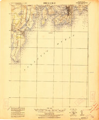
 1921 Stonington1921 Print · USGSCoastal Connecticut and Rhode Island meet here between the wars, where river and rail drive the regional economy. Genealogists can trace family footprints in North Stonington and Westerly, or locate the Silex Mine and the Light House at Stonington.
 - 1922 Map of Newport
 1922 Newport1922 Print · USGSThe Rhode Island coast after the turn of the century shows a landscape of strategic forts and bustling seaside resorts. Trace the path of the Sea View R.R. Co. Electric or locate historic military sites like Fort Adams and Fort Kearney.
 - 1931 Map of Newport
 1931 Newport1931 Print · USGSCoastal Rhode Island just after the Great War shows a landscape of strategic forts and bustling summer colonies. Genealogists and historians can trace the early Sea View R.R. through Narragansett Pier or locate family estates near Ochre Point.
 - 1935 Map of Newport
 1935 Newport1935 Print · USGSNarragansett Bay's military and maritime character is on full display in the mid-1930s. Researchers can trace the Sea View R.R. Co. Electric R.R. or locate coastal fortifications like Fort Adams and Fort Kearney.
Showing maps 1-25 of 156
Top cities of South County
- South Kingstown historical maps
- North Kingstown historical maps
- Westerly historical maps
- Narragansett historical maps
- Hopkinton historical maps
- Richmond historical maps
See more
Frequently asked questions
- What are the different types of historical maps available for South County?
- What is the oldest map of South County?
- Where can I purchase historical maps of South County for my home or office?
- Where can I download high-res historical maps of South County?
- Are there historical topographic maps available for South County?
- Is there historical aerial imagery available for South County?
- Where are historical maps of South County sourced from?