1930s Maps of Rattlesnake, Shiprock Agency
Explore 2 historic maps of Rattlesnake from the 1930s. These maps offer a rare glimpse into what life looked like during the 1930s — showing old roads, neighborhoods, homes, and landmarks that have changed or disappeared over time.
Whether you're researching your family's past, planning a metal detecting trip, or studying how Rattlesnake's landscape evolved across the 1930s, these high-resolution maps are a powerful tool for exploring the history of this region.
- Focus on a specific era: All maps on this page are from the 1930s, giving you a focused view of this time period.
- See what’s changed: Compare century-old streets, trails, and buildings to today's modern landscape using overlays and satellite layers.
- Research with precision: Use these maps for genealogy, historical research, land use analysis, or educational projects.
- View, download, or print: Maps are fully viewable online in high resolution, and can be downloaded or printed for your own records.
Start exploring Rattlesnake's history through authentic maps from the 1930s. This is your window into the past.
Rattlesnake, Shiprock Agency maps
(2)- 1934 Map of Rattlesnake, 1971 Print
 1934 Rattlesnake1971 Print · USGSThe San Juan River basin and the Four Corners intersection are captured here in the mid-1930s. Researchers can trace the early road networks and small settlements of the Navajo Indian Reservation, including Rattlesnake, Cudai, and Bitlabito.
 - 1937 Map of Rattlesnake
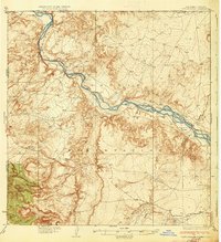 1937 Rattlesnake1937 Print · USGSThe high desert borderlands where New Mexico meets Colorado and Arizona are captured here in the mid-1930s. Researchers can trace early reservation life near the San Juan River and locate historic points like Bitlabito, Cudai, and Rattlesnake.3 unique versions available
End of results
Showing maps 1-2 of 2
Top cities near Rattlesnake
- Shiprock Agency historical maps
- Shiprock historical maps
- Chinle Agency historical maps
- Eastern Navajo Agency historical maps
- Beclabito historical maps
Frequently asked questions
- What are the different types of historical maps available for Rattlesnake?
- What is the oldest map of Rattlesnake?
- Where can I purchase historical maps of Rattlesnake for my home or office?
- Where can I download high-res historical maps of Rattlesnake?
- Are there historical topographic maps available for Rattlesnake?
- Is there historical aerial imagery available for Rattlesnake?
- Where are historical maps of Rattlesnake sourced from?