1960s Maps of Aiken, South Carolina
Explore 6 historic maps of Aiken from the 1960s. These maps offer a rare glimpse into what life looked like during the 1960s — showing old roads, neighborhoods, homes, and landmarks that have changed or disappeared over time.
Whether you're researching your family's past, planning a metal detecting trip, or studying how Aiken's landscape evolved across the 1960s, these high-resolution maps are a powerful tool for exploring the history of this region.
- Focus on a specific era: All maps on this page are from the 1960s, giving you a focused view of this time period.
- See what’s changed: Compare century-old streets, trails, and buildings to today's modern landscape using overlays and satellite layers.
- Research with precision: Use these maps for genealogy, historical research, land use analysis, or educational projects.
- View, download, or print: Maps are fully viewable online in high resolution, and can be downloaded or printed for your own records.
Start exploring Aiken's history through authentic maps from the 1960s. This is your window into the past.
Aiken, SC maps
(6)- 1961 Map of Augusta
 1961 Augusta1961 Print · USGSThe South Carolina lowcountry and CSRA appear here in the early sixties, during a period of massive military and industrial growth. Researchers can trace the development of the Savannah River Plant or locate legacy landmarks like Nelson Ferry and Magnolia Cemetery.2 unique versions available
 - 1962 Map of Augusta
 1962 Augusta1962 Print · USGSThe South Carolina and Georgia borderlands are seen here in the early sixties, showing the rise of the Savannah River Plant and the expansion of Fort Jackson. Researchers can trace old rail lines like the Southern Railway and find landmarks such as St. Pauls Church or the Santee Canal.
 - 1964 Map of Graniteville, 1965 Print
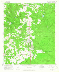
 1964 Graniteville1965 Print · USGSMid-century Graniteville and the Horse Creek Valley are shown here at the height of their industrial era. Researchers can trace family roots through numerous mill villages and local landmarks like Old Langley Cem, Gregg Sch, and the historic Southern Railway corridor.3 unique versions available
 - 1964 Map of Aiken, 1966 Print
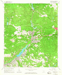
 1964 Aiken1966 Print · USGSAiken at the height of the mid-sixties transition is captured here, balancing its traditional equine culture with new educational and suburban growth. Genealogists and historians can trace family locations near Wayside Ch, Crosland Park, or the campus of the Univ Of S C (Aiken Br).4 unique versions available
 - 1964 Map of Hollow Creek, 1966 Print
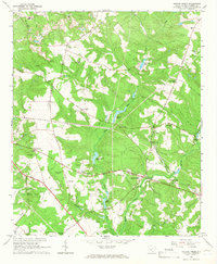 1964 Hollow Creek1966 Print · USGSMid-century Aiken County is captured here at a time when rural life centered around community churches and small schoolhouses. Genealogists can locate family landmarks like Good Hope Cem, the settlement at Spiderweb, and the Sleepy Hollow Sch.3 unique versions available
 - 1965 Map of New Ellenton, 1967 Print
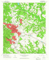
 1965 New Ellenton1967 Print · USGSAiken County was undergoing a massive transformation in the mid-sixties due to the nearby Savannah River Plant. Genealogists and local historians can trace the development of New Ellenton and locate community landmarks like Talatha Ch and the Fairfield Ch.3 unique versions available
End of results
Showing maps 1-6 of 6
Top cities near Aiken
- Augusta historical maps
- North Augusta historical maps
- Burnettown historical maps
- New Ellenton historical maps
- Jackson historical maps
- Trenton historical maps
See more
Top neighborhoods of Aiken
- Kalmia Landing historical maps
- Westcliff historical maps
- Ansley Park historical maps
- Conger Woods historical maps
- Crosland Park historical maps
- Dunbarton Oaks historical maps
See more
Frequently asked questions
- What are the different types of historical maps available for Aiken?
- What is the oldest map of Aiken?
- Where can I purchase historical maps of Aiken for my home or office?
- Where can I download high-res historical maps of Aiken?
- Are there historical topographic maps available for Aiken?
- Is there historical aerial imagery available for Aiken?
- Where are historical maps of Aiken sourced from?