1960s Maps of Allendale County, South Carolina
Explore 6 historic maps of Allendale County from the 1960s. These maps offer a rare glimpse into what life looked like during the 1960s — showing old roads, neighborhoods, homes, and landmarks that have changed or disappeared over time.
Whether you're researching your family's past, planning a metal detecting trip, or studying how Allendale County's landscape evolved across the 1960s, these high-resolution maps are a powerful tool for exploring the history of this region.
- Focus on a specific era: All maps on this page are from the 1960s, giving you a focused view of this time period.
- See what’s changed: Compare century-old streets, trails, and buildings to today's modern landscape using overlays and satellite layers.
- Research with precision: Use these maps for genealogy, historical research, land use analysis, or educational projects.
- View, download, or print: Maps are fully viewable online in high resolution, and can be downloaded or printed for your own records.
Start exploring Allendale County's history through authentic maps from the 1960s. This is your window into the past.
Allendale County, SC maps
(6)- 1960 Map of Savannah
 1960 Savannah1960 Print · USGSCoastal Georgia and the South Carolina Lowcountry are captured in the late fifties, showcasing the intricate web of islands and tidal rivers before modern expansion. Researchers can trace the rail lines of the Atlantic Coast Line or locate sites like Parris Island, Beaufort, and the Tybee Lighthouse.
 - 1961 Map of Augusta
 1961 Augusta1961 Print · USGSThe South Carolina lowcountry and CSRA appear here in the early sixties, during a period of massive military and industrial growth. Researchers can trace the development of the Savannah River Plant or locate legacy landmarks like Nelson Ferry and Magnolia Cemetery.2 unique versions available
 - 1961 Map of Savannah
 1961 Savannah1961 Print · USGSThe Georgia and South Carolina Lowcountry comes alive in this mid-century survey of coastal marshes, barrier islands, and river networks. Genealogists and historians can trace the paths of the Seaboard Air Line RR, locate family sites near Isle of Hope, or study the grounds of Fort Stewart Military Reservation.2 unique versions available
 - 1962 Map of Augusta
 1962 Augusta1962 Print · USGSThe South Carolina and Georgia borderlands are seen here in the early sixties, showing the rise of the Savannah River Plant and the expansion of Fort Jackson. Researchers can trace old rail lines like the Southern Railway and find landmarks such as St. Pauls Church or the Santee Canal.
 - 1964 Map of Millett, 1967 Print
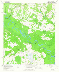 1964 Millett1967 Print · USGSThe Savannah River valley in the early 1960s reveals a rural landscape adapting to the massive presence of the Savannah River Plant. Genealogists and historians can trace community hubs like Millett and Dunbar Store alongside landmarks like Zion Grove Ch.2 unique versions available
 - 1964 Map of Girard NE, 1967 Print
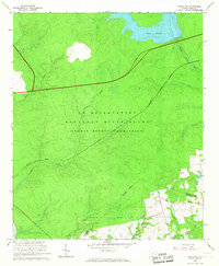 1964 Girard NE1967 Print · USGSBarnwell and Allendale Counties are captured here during the mid-sixties, dominated by the high-security landscape of the Savannah River nuclear site. Researchers can trace the Atlantic Coast Line and locate the isolated Walker Cem near Par Pond.3 unique versions available
End of results
Showing maps 1-6 of 6
Top cities of Allendale County
Frequently asked questions
- What are the different types of historical maps available for Allendale County?
- What is the oldest map of Allendale County?
- Where can I purchase historical maps of Allendale County for my home or office?
- Where can I download high-res historical maps of Allendale County?
- Are there historical topographic maps available for Allendale County?
- Is there historical aerial imagery available for Allendale County?
- Where are historical maps of Allendale County sourced from?