1960s Maps of Anderson, South Carolina
Explore 2 historic maps of Anderson from the 1960s. These maps offer a rare glimpse into what life looked like during the 1960s — showing old roads, neighborhoods, homes, and landmarks that have changed or disappeared over time.
Whether you're researching your family's past, planning a metal detecting trip, or studying how Anderson's landscape evolved across the 1960s, these high-resolution maps are a powerful tool for exploring the history of this region.
- Focus on a specific era: All maps on this page are from the 1960s, giving you a focused view of this time period.
- See what’s changed: Compare century-old streets, trails, and buildings to today's modern landscape using overlays and satellite layers.
- Research with precision: Use these maps for genealogy, historical research, land use analysis, or educational projects.
- View, download, or print: Maps are fully viewable online in high resolution, and can be downloaded or printed for your own records.
Start exploring Anderson's history through authentic maps from the 1960s. This is your window into the past.
Anderson, SC maps
(2)- 1964 Map of Saylors Crossroads, 1965 Print
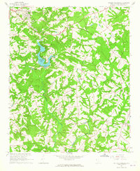 1964 Saylors Crossroads1965 Print · USGSAnderson County's rural heartland is captured here in the mid-sixties, showing a landscape shaped by the Rocky River and the waters of Broadway Lake. Genealogists and local historians can trace the foundations of Saylors Crossroads or locate rural landmarks like New Mount Pleasant Ch and McFall Cem.2 unique versions available
 - 1964 Map of Anderson South, 1965 Print
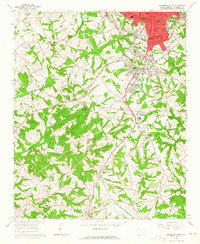 1964 Anderson South1965 Print · USGSThe southern fringes of ANDERSON and the surrounding Piedmont countryside are captured in the early sixties as suburban growth met traditional rural life. Researchers can trace family sites near Silverbrook Cemetery or follow the rails to historic stops like Deans and Starr.3 unique versions available
End of results
Showing maps 1-2 of 2
Top cities near Anderson
- Clemson historical maps
- Piedmont historical maps
- Central historical maps
- Belton historical maps
- Williamston historical maps
- Honea Path historical maps
See more
Top neighborhoods of Anderson
- Highland Acres historical maps
- Marilyn Acres historical maps
- Anderson Gardens historical maps
- Fairfield Acres historical maps
- Colony Hill historical maps
- Concord historical maps
See more
Frequently asked questions
- What are the different types of historical maps available for Anderson?
- What is the oldest map of Anderson?
- Where can I purchase historical maps of Anderson for my home or office?
- Where can I download high-res historical maps of Anderson?
- Are there historical topographic maps available for Anderson?
- Is there historical aerial imagery available for Anderson?
- Where are historical maps of Anderson sourced from?