1920s Maps of Barnwell County, South Carolina
Explore 8 historic maps of Barnwell County from the 1920s. These maps offer a rare glimpse into what life looked like during the 1920s — showing old roads, neighborhoods, homes, and landmarks that have changed or disappeared over time.
Whether you're researching your family's past, planning a metal detecting trip, or studying how Barnwell County's landscape evolved across the 1920s, these high-resolution maps are a powerful tool for exploring the history of this region.
- Focus on a specific era: All maps on this page are from the 1920s, giving you a focused view of this time period.
- See what’s changed: Compare century-old streets, trails, and buildings to today's modern landscape using overlays and satellite layers.
- Research with precision: Use these maps for genealogy, historical research, land use analysis, or educational projects.
- View, download, or print: Maps are fully viewable online in high resolution, and can be downloaded or printed for your own records.
Start exploring Barnwell County's history through authentic maps from the 1920s. This is your window into the past.
Barnwell County, SC maps
(8)- 1920 Map of Ellenton
 1920 Ellenton1920 Print · USGSThe Savannah River valley in the years following the Great War reveals a landscape of river landings and small rail towns. Genealogists can trace family footprints through rural sites like Ellenton, St Marys Church, and the Burton and Myers Store.
 - 1920 Map of Greens Cut
 1920 Greens Cut1920 Print · USGSBurke County, Georgia, and the Savannah River valley are captured here just after the Great War during a period of peak rural density. Genealogists can locate dozens of country institutions like Daniel Grove Church, Red Hill School, and the Old Church Sta along the Central of Georgia line.3 unique versions available
 - 1920 Map of Bamberg
 1920 Bamberg1920 Print · USGSBamberg and Denmark thrived as essential South Carolina railroad junctions during the years following the Great War. Genealogists and local historians can trace rural schoolhouses and landings along the South Fork Edisto River, including the Voorhees Institute, Opossum College, and Old Union Church.2 unique versions available
 - 1920 Map of Talatha
 1920 Talatha1920 Print · USGSAiken and Barnwell Counties are captured here during the era of rural schoolhouses and country parishes. Genealogists can locate specific family landmarks such as Thurmans Mill, Talatha School, and Manoah Church along the historic AUGUSTA road.
 - 1921 Map of Talatha
 1921 Talatha1921 Print · USGSAiken County is captured here in the early twentieth century as a landscape of rural community centers and winding wagon roads. Genealogists can trace family connections through numerous local landmarks like Thalmans Mill, Zion Fair Church, and Wolfpit School.3 unique versions available
 - 1921 Map of Ellenton
 1921 Ellenton1921 Print · USGSThe Savannah River valley in the early 1920s reveals a lost network of riverside landings and agricultural rail stops. Genealogists can trace family footprints at Ellenton, Meyers Mill, and rural sites like Friendship Church or Bethesda School.2 unique versions available
 - 1923 Map of Williston
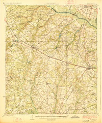
 1923 Williston1923 Print · USGSThe rural landscape of Barnwell County comes to life in the early twenties as it transitioned from rail dependence to a growing road network. Genealogists can locate family landmarks like Boylston Mill, Healing Springs, and more than a dozen local schools including Blessed Home School.
 - 1927 Map of Williston
 1927 Williston1927 Print · USGSBarnwell and Aiken Counties in the early twenties show a landscape centered on the SOUTHERN rail line and the South Fork Edisto River. Genealogists can locate rural landmarks such as Silver Spring Church, Ebenezer School, and historic sites like Woodward Mill.2 unique versions available
End of results
Showing maps 1-8 of 8
Top cities of Barnwell County
- Barnwell historical maps
- Williston historical maps
- Blackville historical maps
- Hilda historical maps
- Snelling historical maps
- Kline historical maps
See more
Frequently asked questions
- What are the different types of historical maps available for Barnwell County?
- What is the oldest map of Barnwell County?
- Where can I purchase historical maps of Barnwell County for my home or office?
- Where can I download high-res historical maps of Barnwell County?
- Are there historical topographic maps available for Barnwell County?
- Is there historical aerial imagery available for Barnwell County?
- Where are historical maps of Barnwell County sourced from?