Old Maps of Barnwell County, South Carolina for Genealogy
Trace your family roots with 65 historic maps of Barnwell County. These high-res maps reveal old neighborhoods, homesites, landmarks, and streets — helping you uncover where your ancestors lived and how the area evolved over time.
- Explore historic neighborhoods: Identify where your relatives may have lived in the 1800s or 1900s.
- Compare maps over time: Trace the changes in streets, buildings, and landmarks for multi-generational research.
- Perfect for genealogy & ancestry research: Used by family historians and researchers to map out lineage and migration.
These maps are an incredible resource for exploring your personal connection to Barnwell County's past.
Barnwell County, SC maps
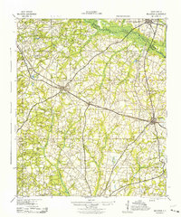
(65)- 1919 Map of Olar
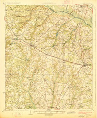
 1919 Olar1919 Print · USGSBamberg and Barnwell counties are shown here just after the Great War, when the river swamps still dictated the path of travel. Genealogists can locate family sites near Hushes Old Mill, Savannah Creek Church, and Stony Bay School.3 unique versions available
 - 1919 Map of Bamberg
 1919 Bamberg1919 Print · USGSThe South Carolina Lowcountry is captured here in the aftermath of the Great War, showing a landscape defined by rail junctions and river landings. Genealogists can trace family roots through numerous rural landmarks like Vorhees Institute, Spires Chapel, and Opossum College.
 - 1919 Map of Allendale
 1919 Allendale1919 Print · USGSThe South Carolina Lowcountry is captured here in the years following the Great War, when rail lines and rural parishes defined the social landscape. Researchers can trace ancestral locations through numerous sites like Jordan Church, Hickory Hill School, and Haygoods Mill.4 unique versions available
 - 1920 Map of Ellenton
 1920 Ellenton1920 Print · USGSThe Savannah River valley in the years following the Great War reveals a landscape of river landings and small rail towns. Genealogists can trace family footprints through rural sites like Ellenton, St Marys Church, and the Burton and Myers Store.
 - 1920 Map of Greens Cut
 1920 Greens Cut1920 Print · USGSBurke County, Georgia, and the Savannah River valley are captured here just after the Great War during a period of peak rural density. Genealogists can locate dozens of country institutions like Daniel Grove Church, Red Hill School, and the Old Church Sta along the Central of Georgia line.3 unique versions available
 - 1920 Map of Bamberg
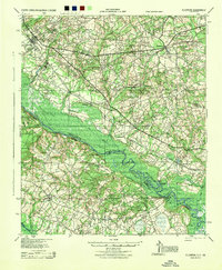
 1920 Bamberg1920 Print · USGSBamberg and Denmark thrived as essential South Carolina railroad junctions during the years following the Great War. Genealogists and local historians can trace rural schoolhouses and landings along the South Fork Edisto River, including the Voorhees Institute, Opossum College, and Old Union Church.2 unique versions available
 - 1920 Map of Talatha
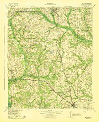
 1920 Talatha1920 Print · USGSAiken and Barnwell Counties are captured here during the era of rural schoolhouses and country parishes. Genealogists can locate specific family landmarks such as Thurmans Mill, Talatha School, and Manoah Church along the historic AUGUSTA road.
 - 1921 Map of Talatha
 1921 Talatha1921 Print · USGSAiken County is captured here in the early twentieth century as a landscape of rural community centers and winding wagon roads. Genealogists can trace family connections through numerous local landmarks like Thalmans Mill, Zion Fair Church, and Wolfpit School.3 unique versions available
 - 1921 Map of Ellenton
 1921 Ellenton1921 Print · USGSThe Savannah River valley in the early 1920s reveals a lost network of riverside landings and agricultural rail stops. Genealogists can trace family footprints at Ellenton, Meyers Mill, and rural sites like Friendship Church or Bethesda School.2 unique versions available
 - 1923 Map of Williston
 1923 Williston1923 Print · USGSThe rural landscape of Barnwell County comes to life in the early twenties as it transitioned from rail dependence to a growing road network. Genealogists can locate family landmarks like Boylston Mill, Healing Springs, and more than a dozen local schools including Blessed Home School.
 - 1927 Map of Williston
 1927 Williston1927 Print · USGSBarnwell and Aiken Counties in the early twenties show a landscape centered on the SOUTHERN rail line and the South Fork Edisto River. Genealogists can locate rural landmarks such as Silver Spring Church, Ebenezer School, and historic sites like Woodward Mill.2 unique versions available
 - 1943 Map of Olar
 1943 Olar1943 Print · USGSThe rural Lowcountry around Olar and Ehrhardt appears here during the early 1940s, showing a landscape shaped by river swamps and rail lines. Genealogists can trace family footprints across dozens of sites like Kearse Chapel, Rizers Chapel, and Folk Sch.2 unique versions available
 - 1943 Map of Allendale
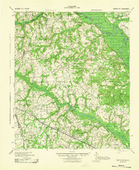
 1943 Allendale1943 Print · USGSCoastal plain settlements and timberlands thrive along the Salkehatchie River in the early 1940s as rail lines connect rural communities. Genealogists can trace family-named landmarks and institutions like Chaney Grove Mill, Hercules School, and Siloam Ch.
 - 1943 Map of Greens Cut
 1943 Greens Cut1943 Print · USGSEastern Georgia during the early 1940s remained a landscape of river landings and rural railroad stops. Genealogists can trace family roots through numerous local landmarks like Old Church Sta, Hatchers Mill, and the settlement of Telfairville.
 - 1943 Map of Bamberg
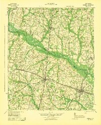 1943 Bamberg1943 Print · USGSMid-century South Carolina comes to life here, showing the intricate rail-and-river network of the Lowcountry. Researchers can locate the Vorhees Institute, trace family ties at Spires Chapel, and find old river access points like Hutto Landing.
 - 1943 Map of Augusta East
 1943 Augusta East1943 Print · USGSThe Savannah River valley along the Georgia and South Carolina border is shown here in the early 1940s, just before significant regional changes. Genealogists can trace hundreds of rural landmarks, including Ellenton, the Downer Institute, and several mills like Hatchers Mill.
 - 1943 Map of Williston
 1943 Williston1943 Print · USGSBarnwell County in the early 1940s was a landscape of rail-linked towns and scattered rural communities. Genealogists can trace family roots through numerous local landmarks, including the Blessed Home Sch, Woodward Mill, and the community of Healing Springs.2 unique versions available
 - 1943 Map of Talatha
 1943 Talatha1943 Print · USGSAiken and Barnwell counties are captured here in the early 1940s, showing a rural landscape organized around deep-rooted churches and small schoolhouses. Researchers can trace ancestral locations near Thalmans Mill, Treadway Ch, or Fairview Sch along the many creek branches.
 - 1944 Map of Ellenton
 1944 Ellenton1944 Print · USGSIn the mid-1940s, this area of the Savannah River valley was a thriving agricultural landscape centered on Ellenton and Dunbarton. Genealogists can trace family footprints through sites like Bethesda Sch, Daisy May Ch, and the local Burton & Myers Store.
 - 1954 Map of Augusta
 1954 Augusta1954 Print · USGSThe Savannah River valley and South Carolina Midlands are captured here during a period of post-war growth. Researchers can trace the rail-and-river economy through the Southern RR corridor and locate historic settlements like Aiken, Orangeburg, and Sumter.
 - 1957 Map of Augusta, 1966 Print
 1957 Augusta1966 Print · USGSThe Savannah River and Santee basins are captured here during a period of massive military and industrial expansion in the late fifties. Genealogists can trace family footprints across Four Hole Swamp or near the Savannah River Plant.3 unique versions available
 - 1958 Map of Augusta
 1958 Augusta1958 Print · USGSThe borderlands between Georgia and South Carolina come alive in the 1950s, showing the early footprint of the Savannah River Plant. Genealogists and historians can trace rail-dependent towns and rural landmarks from Orangeburg to the Fort Jackson Military Reservation.
 - 1961 Map of Augusta
 1961 Augusta1961 Print · USGSThe South Carolina lowcountry and CSRA appear here in the early sixties, during a period of massive military and industrial growth. Researchers can trace the development of the Savannah River Plant or locate legacy landmarks like Nelson Ferry and Magnolia Cemetery.2 unique versions available
 - 1962 Map of Augusta
 1962 Augusta1962 Print · USGSThe South Carolina and Georgia borderlands are seen here in the early sixties, showing the rise of the Savannah River Plant and the expansion of Fort Jackson. Researchers can trace old rail lines like the Southern Railway and find landmarks such as St. Pauls Church or the Santee Canal.
 - 1963 Map of New Ellenton SE, 1967 Print
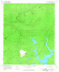 1963 New Ellenton SE1967 Print · USGSBarnwell County was undergoing a massive industrial transformation in the early sixties as federal operations expanded. Local researchers can trace the development of the Savannah River Plant and its impact on waterways like Par Pond and Tinker Creek.3 unique versions available
Showing maps 1-25 of 65
Top cities of Barnwell County
- Barnwell historical maps
- Williston historical maps
- Blackville historical maps
- Hilda historical maps
- Snelling historical maps
- Kline historical maps
See more
Frequently asked questions
- What are the different types of historical maps available for Barnwell County?
- What is the oldest map of Barnwell County?
- Where can I purchase historical maps of Barnwell County for my home or office?
- Where can I download high-res historical maps of Barnwell County?
- Are there historical topographic maps available for Barnwell County?
- Is there historical aerial imagery available for Barnwell County?
- Where are historical maps of Barnwell County sourced from?