1950s Maps of Beaufort, South Carolina
Explore 5 historic maps of Beaufort from the 1950s. These maps offer a rare glimpse into what life looked like during the 1950s — showing old roads, neighborhoods, homes, and landmarks that have changed or disappeared over time.
Whether you're researching your family's past, planning a metal detecting trip, or studying how Beaufort's landscape evolved across the 1950s, these high-resolution maps are a powerful tool for exploring the history of this region.
- Focus on a specific era: All maps on this page are from the 1950s, giving you a focused view of this time period.
- See what’s changed: Compare century-old streets, trails, and buildings to today's modern landscape using overlays and satellite layers.
- Research with precision: Use these maps for genealogy, historical research, land use analysis, or educational projects.
- View, download, or print: Maps are fully viewable online in high resolution, and can be downloaded or printed for your own records.
Start exploring Beaufort's history through authentic maps from the 1950s. This is your window into the past.
Beaufort, SC maps
(5)- 1956 Map of Frogmore, 1957 Print
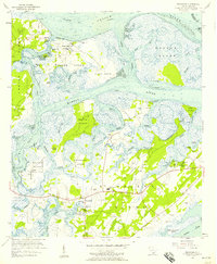 1956 Frogmore1957 Print · USGSCoastal Beaufort County in the mid-fifties is a labyrinth of tidal marsh and island life. Genealogists can trace family heritage through numerous landmarks like Penn Community Services, Brick Ch, and the Scottsville Cem.3 unique versions available
 - 1956 Map of Parris Island, 1957 Print
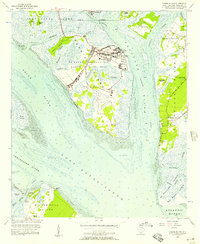 1956 Parris Island1957 Print · USGSThe Lowcountry landscape of the mid-fifties is captured here, centering on the military operations of Parris Island and the neighboring islands. Genealogists and historians can trace the foundations of the Marine Recruit Depot alongside coastal landmarks like Fort Fremont and the Elliot Cem.5 unique versions available
 - 1957 Map of Savannah, 1967 Print
 1957 Savannah1967 Print · USGSThe Lowcountry and Georgia coastal plain are shown here in the late fifties, prior to modern expansion. Researchers can trace the rail-and-river economy through the Central of Georgia lines and the Ogeechee River wetlands.4 unique versions available
 - 1958 Map of Beaufort, 1960 Print
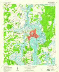 1958 Beaufort1960 Print · USGSPort Royal Island and Beaufort are shown during a period of significant military and maritime activity in the late fifties. Genealogists and historians can trace family-named sites like Rose Hill Cem and Hazel Farm, or locate the Ruins (Fort Frederick) along the Beaufort River.5 unique versions available
 - 1959 Map of Fort Fremont
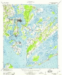 1959 Fort Fremont1959 Print · USGSThe South Carolina Sea Islands are captured here in the mid-twentieth century, emphasizing the deep connection between the tides and local settlement. Genealogists and historians can trace the rail lines to Beaufort Sta, locate the grounds of Ft Fremont, and explore the layout of Parris Island.
End of results
Showing maps 1-5 of 5
Top cities near Beaufort
- Hilton Head Island historical maps
- Port Royal historical maps
- Bluffton historical maps
- Hardeeville historical maps
Top neighborhoods of Beaufort
- Mink Point Plantation historical maps
- Waterford Place historical maps
- The Point historical maps
- Beaufort Historic District historical maps
Frequently asked questions
- What are the different types of historical maps available for Beaufort?
- What is the oldest map of Beaufort?
- Where can I purchase historical maps of Beaufort for my home or office?
- Where can I download high-res historical maps of Beaufort?
- Are there historical topographic maps available for Beaufort?
- Is there historical aerial imagery available for Beaufort?
- Where are historical maps of Beaufort sourced from?