1940s Maps of Awendaw, South Carolina
Explore 6 historic maps of Awendaw from the 1940s. These maps offer a rare glimpse into what life looked like during the 1940s — showing old roads, neighborhoods, homes, and landmarks that have changed or disappeared over time.
Whether you're researching your family's past, planning a metal detecting trip, or studying how Awendaw's landscape evolved across the 1940s, these high-resolution maps are a powerful tool for exploring the history of this region.
- Focus on a specific era: All maps on this page are from the 1940s, giving you a focused view of this time period.
- See what’s changed: Compare century-old streets, trails, and buildings to today's modern landscape using overlays and satellite layers.
- Research with precision: Use these maps for genealogy, historical research, land use analysis, or educational projects.
- View, download, or print: Maps are fully viewable online in high resolution, and can be downloaded or printed for your own records.
Start exploring Awendaw's history through authentic maps from the 1940s. This is your window into the past.
Awendaw, SC maps
(6)- 1943 Map of Sewee Bay
 1943 Sewee Bay1943 Print · USGSThe Charleston County coastline in the early 1940s reveals a quiet landscape of rural schools and tidal marshes before the onset of modern coastal development. Local historians can trace the positions of Twelvemile Sch and Eighteenmile Sch or explore the waterfronts of Woodville and Andersonville.
 - 1943 Map of Bulls Island
 1943 Bulls Island1943 Print · USGSCoastal South Carolina during the war years reveals an intricate maritime landscape of barrier islands and tidal marshes. Researchers can trace historic landmarks like the Old Fort on Bulls Island or navigate the winding reaches of Vanderhorst Creek and the Intercoastal Waterway.
 - 1943 Map of Awendaw, 1962 Print
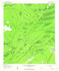
 1943 Awendaw1962 Print · USGSThe Charleston County coast during the 1940s reveals a landscape defined by tidal marshes and timberlands. Genealogists and historians can trace the footprints of Tibwin Plantation and Laurel Hill Plantation or locate the St James Sch near Awendaw.5 unique versions available
 - 1943 Map of Ocean Bay, 1962 Print
 1943 Ocean Bay1962 Print · USGSCoastal South Carolina during the war years shows a landscape of dense wetlands and forest industry. Genealogists and historians can trace the Old Railroad Grade past the Halfway Creek Sch and the Ocean Grove Ch.4 unique versions available
 - 1948 Map of James Island
 1948 James Island1948 Print · USGSThe South Carolina coast around the harbor city appeared in this postwar period as a network of naval defenses and established sea island communities. Trace the roads and waterways connecting Charleston to Fort Sumter, Mt Pleasant, and the Isle of Palms.2 unique versions available
 - 1949 Map of Georgetown, 1953 Print
 1949 Georgetown1953 Print · USGSThe South Carolina coast and North Carolina borderlands appear here in the mid-century, prior to the major modern development of the Grand Strand. Genealogists and historians can trace the rail networks of the Seaboard Air Line Railroad and locate coastal landmarks from Fort Caswell to McClellanville.
End of results
Showing maps 1-6 of 6
Top cities near Awendaw
- Charleston historical maps
- Mount Pleasant historical maps
- Isle of Palms historical maps
- McClellanville historical maps
Frequently asked questions
- What are the different types of historical maps available for Awendaw?
- What is the oldest map of Awendaw?
- Where can I purchase historical maps of Awendaw for my home or office?
- Where can I download high-res historical maps of Awendaw?
- Are there historical topographic maps available for Awendaw?
- Is there historical aerial imagery available for Awendaw?
- Where are historical maps of Awendaw sourced from?