1950s Maps of Awendaw, South Carolina
Explore 2 historic maps of Awendaw from the 1950s. These maps offer a rare glimpse into what life looked like during the 1950s — showing old roads, neighborhoods, homes, and landmarks that have changed or disappeared over time.
Whether you're researching your family's past, planning a metal detecting trip, or studying how Awendaw's landscape evolved across the 1950s, these high-resolution maps are a powerful tool for exploring the history of this region.
- Focus on a specific era: All maps on this page are from the 1950s, giving you a focused view of this time period.
- See what’s changed: Compare century-old streets, trails, and buildings to today's modern landscape using overlays and satellite layers.
- Research with precision: Use these maps for genealogy, historical research, land use analysis, or educational projects.
- View, download, or print: Maps are fully viewable online in high resolution, and can be downloaded or printed for your own records.
Start exploring Awendaw's history through authentic maps from the 1950s. This is your window into the past.
Awendaw, SC maps
(2)- 1959 Map of Bull Island, 1960 Print
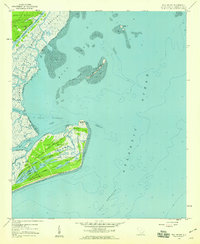 1959 Bull Island1960 Print · USGSThe South Carolina coast near Charleston appears in the late fifties as a landscape of protected marshes and maritime forests. Genealogists and historians can trace family sites at Wilson Cem or explore the wild paths of Cape Romain Island along Old Fort Road.3 unique versions available
 - 1959 Map of Sewee Bay, 1960 Print
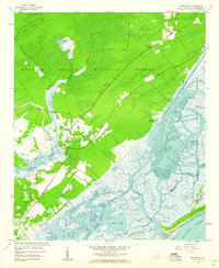 1959 Sewee Bay1960 Print · USGSThe South Carolina Lowcountry coastline in the late fifties is captured here through the dense forests and expansive tidal marshes of Charleston County. Genealogists and researchers can trace community roots through Wappetaw Cem, Sewee Ch, and the small settlement at Woodville.4 unique versions available
End of results
Showing maps 1-2 of 2
Top cities near Awendaw
- Charleston historical maps
- Mount Pleasant historical maps
- Isle of Palms historical maps
- McClellanville historical maps
Frequently asked questions
- What are the different types of historical maps available for Awendaw?
- What is the oldest map of Awendaw?
- Where can I purchase historical maps of Awendaw for my home or office?
- Where can I download high-res historical maps of Awendaw?
- Are there historical topographic maps available for Awendaw?
- Is there historical aerial imagery available for Awendaw?
- Where are historical maps of Awendaw sourced from?