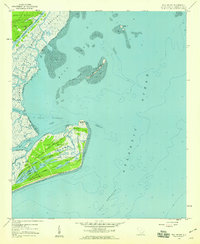
1959 Map of Bull Island
USGS Topo · Published 1960About this map
The Cape Romain Island shoreline and the dense marshlands of the South Carolina coast define this 1959 coastal study. Dominated by the Cape Romain National Wildlife Refuge, the landscape is a complex network of tidal flats and interior ponds such as Big Pond and Moccasin Pond. The presence of Wilson Cem and Sewee Cem near the edge of the Francis Marion National Forest offers specific points of interest for genealogists tracing local families in the Charleston area.
Find a feature on this map
36 named features on this map. Tap any name to fly to it.
Don’t see what you’re looking for? This feature index may not catch every label — zoom into the map to look around manually.
Map Details
Editions of this 1959 Bull Island Map
3 editions found
Other maps of this area

1919 · Capers Island
USGS Topo · 1:21,120

1919 · Bulls Island
USGS Topo · 1:21,120

1919 · Sewee Bay
USGS Topo · 1:21,120

1942 · Mc Clellanville
USGS Topo · 1:24,000

1943 · Capers Island
USGS Topo · 1:24,000

1943 · Sewee Bay
USGS Topo · 1:24,000

1943 · Bulls Island
USGS Topo · 1:24,000

1943 · Awendaw
USGS Topo · 1:24,000

1943 · Ocean Bay
USGS Topo · 1:24,000

1948 · James Island
USGS Topo · 1:250,000