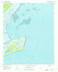
1959 Map of Bull Island
USGS Topo · Published 1975About this map
Cape Romain National Wildlife Refuge dominates this coastal landscape, capturing a stretch of the South Carolina lowcountry defined by its dynamic barrier islands and tidal marshes. On Cape Romain National Wildlife Refuge (Bull Island), a complex network of freshwater impoundments like Upper Summerhouse Pond and Moccasin Pond sits just behind the primary dunes, illustrating the delicate balance of coastal ecosystems. Evidence of human history is scattered across the island, from the landmark Lighthouse and Lookout Tower to the site of Fort Old and an old Cemetery. To the north, the Intracoastal Waterway cuts through the marshes of the Francis Marion National Forest, where Wilson Cemetery and Sewe Camp mark the edge of the mainland. The map tracks the shifting sands of Bird Island Shoal and the expansive Tidal Flat areas that characterize Bulls Bay.
Find a feature on this map
40 named features on this map. Tap any name to fly to it.
Don’t see what you’re looking for? This feature index may not catch every label — zoom into the map to look around manually.
Map Details
Editions of this 1959 Bull Island Map
3 editions found
Other maps of this area

1919 · Capers Island
USGS Topo · 1:21,120

1919 · Bulls Island
USGS Topo · 1:21,120

1919 · Sewee Bay
USGS Topo · 1:21,120

1942 · Mc Clellanville
USGS Topo · 1:24,000

1943 · Capers Island
USGS Topo · 1:24,000

1943 · Sewee Bay
USGS Topo · 1:24,000

1943 · Bulls Island
USGS Topo · 1:24,000

1943 · Awendaw
USGS Topo · 1:24,000

1943 · Ocean Bay
USGS Topo · 1:24,000

1948 · James Island
USGS Topo · 1:250,000