1960s Maps of Awendaw, South Carolina
Explore 3 historic maps of Awendaw from the 1960s. These maps offer a rare glimpse into what life looked like during the 1960s — showing old roads, neighborhoods, homes, and landmarks that have changed or disappeared over time.
Whether you're researching your family's past, planning a metal detecting trip, or studying how Awendaw's landscape evolved across the 1960s, these high-resolution maps are a powerful tool for exploring the history of this region.
- Focus on a specific era: All maps on this page are from the 1960s, giving you a focused view of this time period.
- See what’s changed: Compare century-old streets, trails, and buildings to today's modern landscape using overlays and satellite layers.
- Research with precision: Use these maps for genealogy, historical research, land use analysis, or educational projects.
- View, download, or print: Maps are fully viewable online in high resolution, and can be downloaded or printed for your own records.
Start exploring Awendaw's history through authentic maps from the 1960s. This is your window into the past.
Awendaw, SC maps
(3)- 1967 Map of Georgetown
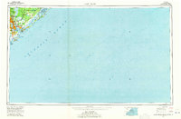
 1967 Georgetown1967 Print · USGSThe South Carolina Lowcountry and Grand Strand meet in the late sixties, showcasing a coastal landscape transitioning from river-based industry to seaside tourism. Researchers can trace the Intracoastal Waterway past Georgetown or locate historical sites like Fort Fisher and Murrells Inlet.
 - 1968 Map of James Island
 1968 James Island1968 Print · USGSThe South Carolina Lowcountry in the late sixties shows a transition between its historic coastal defenses and modern expansion. Trace the harbor landscape from Charleston to the barrier islands, finding landmarks like Fort Sumter, Fort Moultrie, and Carolina Skyways.
 - 1969 Map of James Island, 1971 Print
 1969 James Island1971 Print · USGSThe South Carolina coast and Charleston Harbor are documented here in the late sixties, showing a landscape defined by naval history and barrier island growth. Genealogists and historians can trace the footprint of Scanlonville, Folly Beach, and the historic Ft Moultrie.2 unique versions available
End of results
Showing maps 1-3 of 3
Top cities near Awendaw
- Charleston historical maps
- Mount Pleasant historical maps
- Isle of Palms historical maps
- McClellanville historical maps
Frequently asked questions
- What are the different types of historical maps available for Awendaw?
- What is the oldest map of Awendaw?
- Where can I purchase historical maps of Awendaw for my home or office?
- Where can I download high-res historical maps of Awendaw?
- Are there historical topographic maps available for Awendaw?
- Is there historical aerial imagery available for Awendaw?
- Where are historical maps of Awendaw sourced from?