1980s Maps of Clarendon County, South Carolina
Explore 14 historic maps of Clarendon County from the 1980s. These maps offer a rare glimpse into what life looked like during the 1980s — showing old roads, neighborhoods, homes, and landmarks that have changed or disappeared over time.
Whether you're researching your family's past, planning a metal detecting trip, or studying how Clarendon County's landscape evolved across the 1980s, these high-resolution maps are a powerful tool for exploring the history of this region.
- Focus on a specific era: All maps on this page are from the 1980s, giving you a focused view of this time period.
- See what’s changed: Compare century-old streets, trails, and buildings to today's modern landscape using overlays and satellite layers.
- Research with precision: Use these maps for genealogy, historical research, land use analysis, or educational projects.
- View, download, or print: Maps are fully viewable online in high resolution, and can be downloaded or printed for your own records.
Start exploring Clarendon County's history through authentic maps from the 1980s. This is your window into the past.
Clarendon County, SC maps
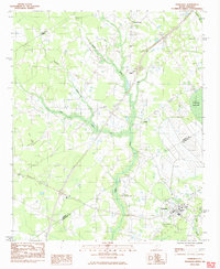
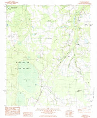
(14)- 1980 Map of Pinewood
 1980 Pinewood1980 Print · USGSCoastal plain agriculture and wetlands define the Sumter and Clarendon county border in the early 1980s. Genealogists and historians can trace rail-side communities like Pinewood and Rimini or locate rural landmarks such as St Peters Ch and Elliott Millpond.2 unique versions available
 - 1980 Map of Saint Paul
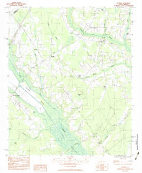
 1980 Saint Paul1980 Print · USGSThe Santee River basin is shown here in the early eighties as a hub of conservation and rural heritage. Genealogists and historians can trace local landmarks like St Phillips Ch, the Liberty Hill Sch, and the ancient Indian Mound near Cantey Bay.2 unique versions available
 - 1980 Map of Jordan
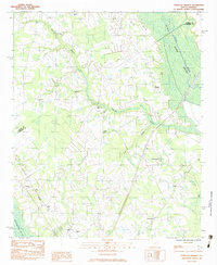
 1980 Jordan1980 Print · USGSClarendon County in the early eighties shows a landscape of rural crossroads and growing lakeside recreation along the Santee. Genealogists and historians can locate several country churches like St Matthews Ch and trace the Old RR Grade near Jordan.2 unique versions available
 - 1980 Map of Manning
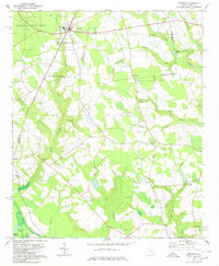
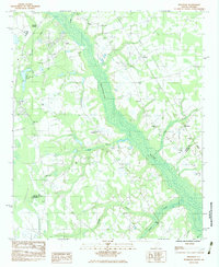
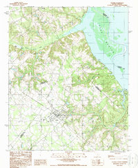
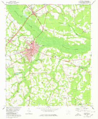 1980 Manning1980 Print · USGSClarendon County's lowcountry landscape is frozen in time during the late twentieth century as the city of Manning expands near Ox Swamp. Researchers can trace rural lineages through local landmarks like Alcolu, Baggette Crossroads, and Emmanuel Ch.
 - 1983 Map of Turbeville
 1983 Turbeville1983 Print · USGSThe swamp-and-timber country of the Santee River basin comes into focus during the early 1980s. Genealogists and local historians can trace the growth of Turbeville and find rural landmarks like Mt Sinai Ch, Hudgens Academy, and the unique terrain of Woods Bay State Park.
 - 1983 Map of Sardinia
 1983 Sardinia1983 Print · USGSClarendon County in the early eighties shows a rural landscape defined by vast wetlands and small farming communities. Genealogists can trace family landmarks like Ebenezer Cem or the New Zion Lookout Tower and locate centers of local life at Gable and Sardinia.
 - 1983 Map of Tearcoat Branch
 1983 Tearcoat Branch1983 Print · USGSSumter and Clarendon counties are captured here in the early eighties, where agricultural life centers on the fringes of the Black River Swamp. Genealogists and historians can trace local family roots through sites like Brunsons Cem, Harvin, and Westminster Ch.
 - 1983 Map of Brogdon
 1983 Brogdon1983 Print · USGSThe Pocotaligo River wetlands and the rural communities of Sumter County are frozen in time during the early eighties. Researchers can trace the lineage of local parishes and landmarks like New Bethel Ch, Bradford Cem, and the Seaboard railroad line.
 - 1983 Map of Privateer, 1984 Print
 1983 Privateer1984 Print · USGSThe Sumter County countryside comes into focus in the early eighties as a landscape of timber, training ranges, and small crossroads. Genealogists and historians can locate Smith Cem, trace the Seaboard line, or explore Harvins Crossroads.2 unique versions available
 - 1985 Map of Saint George, 1986 Print
 1985 Saint George1986 Print · USGSThe South Carolina Lowcountry in the mid-eighties shows a landscape defined by the great reservoirs and the meandering Edisto River. Researchers can trace the rail corridors of the Southern Railway and find rural settlements like Harleyville, Smoaks, and Grover.
 - 1986 Map of Kingstree
 1986 Kingstree1986 Print · USGSThe South Carolina Lowcountry in the mid-eighties shows a landscape defined by the Black River and the growing coastal communities of the Grand Strand. Researchers can trace historic river settlements and rail stops like Salters Depot, Pamplico, and Hemingway.2 unique versions available
 - 1986 Map of Sumter
 1986 Sumter1986 Print · USGSMid-South Carolina in the mid-eighties reveals a landscape of massive river bottomlands and significant military installations. Genealogists and historians can trace the rural networks around Fort Motte, Lone Star, and Sardinia alongside Lake Marion.
 - 1988 Map of Elloree
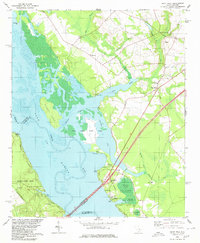
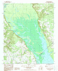
 1988 Elloree1988 Print · USGSThe town of Elloree and the western shores of Lake Marion are captured here in the late eighties as the region balanced agriculture with lakeside recreation. Researchers can pinpoint Elloree, the settlement of Lone Star, and several local cemeteries alongside the waters of Santee State Park.
 - 1988 Map of Lone Star
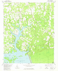
 1988 Lone Star1988 Print · USGSThe Santee River lowlands and the vast waters of Lake Marion are captured here in the late 1980s. Local historians and genealogists can trace the rural communities of Lone Star and Rimini, alongside landmarks like Fulton Crossroads and Weeks Landing.
End of results
Showing maps 1-14 of 14
Top cities of Clarendon County
Frequently asked questions
- What are the different types of historical maps available for Clarendon County?
- What is the oldest map of Clarendon County?
- Where can I purchase historical maps of Clarendon County for my home or office?
- Where can I download high-res historical maps of Clarendon County?
- Are there historical topographic maps available for Clarendon County?
- Is there historical aerial imagery available for Clarendon County?
- Where are historical maps of Clarendon County sourced from?