1990s Maps of Clarendon County, South Carolina
Explore 6 historic maps of Clarendon County from the 1990s. These maps offer a rare glimpse into what life looked like during the 1990s — showing old roads, neighborhoods, homes, and landmarks that have changed or disappeared over time.
Whether you're researching your family's past, planning a metal detecting trip, or studying how Clarendon County's landscape evolved across the 1990s, these high-resolution maps are a powerful tool for exploring the history of this region.
- Focus on a specific era: All maps on this page are from the 1990s, giving you a focused view of this time period.
- See what’s changed: Compare century-old streets, trails, and buildings to today's modern landscape using overlays and satellite layers.
- Research with precision: Use these maps for genealogy, historical research, land use analysis, or educational projects.
- View, download, or print: Maps are fully viewable online in high resolution, and can be downloaded or printed for your own records.
Start exploring Clarendon County's history through authentic maps from the 1990s. This is your window into the past.
Clarendon County, SC maps
(6)- 1990 Map of Hebron Crossroads
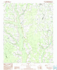 1990 Hebron Crossroads1990 Print · USGSClarendon and Williamsburg Counties in the early 1980s are defined by their deep swamp drainage and crossroads communities. Genealogists and local historians can trace family roots through Hebron Crossroads, Union Crossroads, and the grounds of Holly Tree Plantation.
 - 1990 Map of Olanta
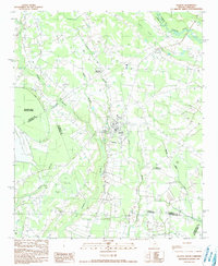 1990 Olanta1990 Print · USGSThe South Carolina coastal plain in the late twentieth century is captured here as a landscape of unique Carolina Bays and rural crossroads. Researchers can trace landownership patterns near Olanta or explore the preserved wetlands of Woods Bay State Park and Fuller Bay.
 - 1990 Map of Saint George
 1990 Saint George1990 Print · USGSThe South Carolina Lowcountry in the early nineties reveals a complex network of river systems and massive reservoirs. Genealogists and local historians can trace the development of inland settlements like St George and Branchville or explore the wetlands of Four Hole Swamp.
 - 1990 Map of Sumter
 1990 Sumter1990 Print · USGSCentral South Carolina's river systems and military landscapes are captured here during the late twentieth century. Genealogists and historians can trace the growth of Sumter or locate rural communities such as Wedgefield and Kingville near the Congaree River.
 - 1990 Map of Workman
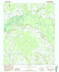 1990 Workman1990 Print · USGSWilliamsburg and Clarendon counties meet along the winding Black River in this early 1980s survey of the South Carolina Lowcountry. Genealogists and historians can trace family lands near Workman, Mouzon, and the many wetlands like Pudding Swamp.
 - 1994 Map of Saint Paul, 1999 Print
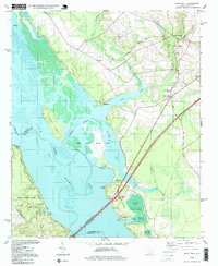 1994 Saint Paul1999 Print · USGSThe Lake Santee shoreline and its surrounding wetlands are captured here in the mid-1990s as modern bridges began to dominate the landscape. Genealogists can trace family landmarks at Saint Paul, St Phillips Ch, and the Liberty Hill Sch.
End of results
Showing maps 1-6 of 6
Top cities of Clarendon County
Frequently asked questions
- What are the different types of historical maps available for Clarendon County?
- What is the oldest map of Clarendon County?
- Where can I purchase historical maps of Clarendon County for my home or office?
- Where can I download high-res historical maps of Clarendon County?
- Are there historical topographic maps available for Clarendon County?
- Is there historical aerial imagery available for Clarendon County?
- Where are historical maps of Clarendon County sourced from?