1900s (20th Century) Maps of Georgetown, South Carolina
Explore 8 historic maps of Georgetown from the 1900s (20th Century). These maps offer a rare glimpse into what life looked like during the 1900s — showing old roads, neighborhoods, homes, and landmarks that have changed or disappeared over time.
Whether you're researching your family's past, planning a metal detecting trip, or studying how Georgetown's landscape evolved across the 1900s, these high-resolution maps are a powerful tool for exploring the history of this region.
- Focus on a specific era: All maps on this page are from the 1900s, giving you a focused view of this time period.
- See what’s changed: Compare century-old streets, trails, and buildings to today's modern landscape using overlays and satellite layers.
- Research with precision: Use these maps for genealogy, historical research, land use analysis, or educational projects.
- View, download, or print: Maps are fully viewable online in high resolution, and can be downloaded or printed for your own records.
Start exploring Georgetown's history through authentic maps from the 1900s. This is your window into the past.
Georgetown, SC maps
(8)- 1943 Map of Georgetown North, 1962 Print
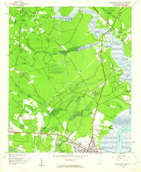 1943 Georgetown North1962 Print · USGSGeorgetown and the surrounding Lowcountry plantations are captured during the mid-1940s as the river-based economy met new wartime demands. Genealogists and historians can trace family-named sites like Lark Hill Plantation, Johnson Corner, and Mt Zion Ch.3 unique versions available
 - 1943 Map of Georgetown South, 1976 Print
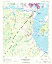 1943 Georgetown South1976 Print · USGSGeorgetown and the surrounding South Carolina Lowcountry are captured here during the mid-twentieth century as traditional river life shifted. Genealogists and historians can trace family-named estates like Friend Field Plantation or locate community centers like Maryville and Pennyroyal School.2 unique versions available
 - 1947 Map of Georgetown South
 1947 Georgetown South1947 Print · USGSCoastal South Carolina is captured here in the late 1940s, showing a landscape of historic riverfront plantations and emerging military infrastructure. Genealogists and local researchers can trace family lands near Belle Isle Gardens or locate rural landmarks like Pennyroyal School and the Winyah Fire Tower.
 - 1949 Map of Georgetown, 1953 Print
 1949 Georgetown1953 Print · USGSThe South Carolina coast and North Carolina borderlands appear here in the mid-century, prior to the major modern development of the Grand Strand. Genealogists and historians can trace the rail networks of the Seaboard Air Line Railroad and locate coastal landmarks from Fort Caswell to McClellanville.
 - 1967 Map of Georgetown
 1967 Georgetown1967 Print · USGSThe South Carolina Lowcountry and Grand Strand meet in the late sixties, showcasing a coastal landscape transitioning from river-based industry to seaside tourism. Researchers can trace the Intracoastal Waterway past Georgetown or locate historical sites like Fort Fisher and Murrells Inlet.
 - 1968 Map of Georgetown South
 1968 Georgetown South1968 Print · USGSGeorgetown and the surrounding Lowcountry plantations are captured here in the mid-1940s, showing a landscape of coastal change. Genealogists and historians can trace family roots through sites like Friend Field Plantation, Pennyroyal School, and St Peters Church.
 - 1974 Map of Georgetown, 1978 Print
 1974 Georgetown1978 Print · USGSThe Carolina coast and Pee Dee region are shown here in the mid-seventies, just as the Grand Strand was maturing into a premier destination. Researchers can trace the inland rail corridors of the Seaboard Coast Line Railroad or explore the coastal reaches of the Cape Romain National Wildlife Refuge and Myrtle Beach State Park.2 unique versions available
 - 1986 Map of Georgetown
 1986 Georgetown1986 Print · USGSThe South Carolina Lowcountry is captured here in the mid-1980s, centered on the historic port of Georgetown and its surrounding wetlands. Researchers can trace the river-fed economy and land patterns of Waccamaw Neck, Hampton Plantation State Park, and the timber-rich Francis Marion National Forest.2 unique versions available
End of results
Showing maps 1-8 of 8
Top cities near Georgetown
- Murrells Inlet historical maps
- Litchfield Beach historical maps
- DeBordieu Colony historical maps
- Pawleys Island historical maps
Top neighborhoods of Georgetown
Frequently asked questions
- What are the different types of historical maps available for Georgetown?
- What is the oldest map of Georgetown?
- Where can I purchase historical maps of Georgetown for my home or office?
- Where can I download high-res historical maps of Georgetown?
- Are there historical topographic maps available for Georgetown?
- Is there historical aerial imagery available for Georgetown?
- Where are historical maps of Georgetown sourced from?