
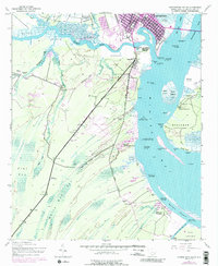
1943 Map of Georgetown South
USGS Topo · Published 1976About this map
Georgetown and its surrounding coastal lowlands are defined by the convergence of the Pee Dee River, Waccamaw River, and Sampit River into the expansive Winyah Bay. This mid-century survey documents a landscape of historical transitions, where numerous Abandoned Rice Fields along the riverbanks signify the decline of a once-dominant agricultural system. The map identifies several prominent estates, including Friend Field Plantation, Hobcaw Plantation, and Estherville Plantation, which anchor the rural geography outside the urban center. In the southern portion of the quadrangle, the Estherville Minim Creek Canal and the Western Channel illustrate the importance of water management and navigation for the region. Social and civic life is marked by local landmarks like St Peters Church, Mt Olive Ch, and the Pennyroyal School, while the County Airport and the Seaboard Coast Line railroad represent the area's mid-20th-century infrastructure. Dense wetlands such as White Oak Bay and Flat Bay separate the inland settlements from the coastal islands like Rabbit Island.
Find a feature on this map
57 named features on this map. Tap any name to fly to it.
Don’t see what you’re looking for? This feature index may not catch every label — zoom into the map to look around manually.
Map Details
Editions of this 1943 Georgetown South Map
2 editions found
Other maps of this area

1942 · Santee Point
USGS Topo · 1:24,000

1942 · North Island
USGS Topo · 1:24,000

1942 · Waverly Mills
USGS Topo · 1:24,000

1943 · Olin
USGS Topo · 1:31,680

1943 · Kilsock Bay
USGS Topo · 1:24,000

1943 · Santee
USGS Topo · 1:24,000

1943 · Georgetown North
USGS Topo · 1:24,000

1943 · Minim Island
USGS Topo · 1:24,000

1947 · Georgetown South
USGS Topo · 1:24,000

1949 · Georgetown
USGS Topo · 1:250,000