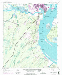
1943 Map of Georgetown South
USGS Topo · Published 1989About this map
The Sampit River and Winyah Bay define the landscape of this coastal region, where a centuries-old plantation economy transition into the mid-20th century. The intricate network of abandoned rice fields along the riverbanks near Georgetown serves as a silent witness to the area's massive historical rice production. Large estates such as Friend Field Plantation, Hobcaw Plantation, and Estherville Plantation dominate the shoreline and inland acreage, reflecting the persistent land-use patterns of the South Carolina Lowcountry.
Find a feature on this map
54 named features on this map. Tap any name to fly to it.
Don’t see what you’re looking for? This feature index may not catch every label — zoom into the map to look around manually.
Map Details
Editions of this 1943 Georgetown South Map
2 editions found
Other maps of this area

1942 · Santee Point
USGS Topo · 1:24,000

1942 · North Island
USGS Topo · 1:24,000

1942 · Waverly Mills
USGS Topo · 1:24,000

1943 · Olin
USGS Topo · 1:31,680

1943 · Kilsock Bay
USGS Topo · 1:24,000

1943 · Santee
USGS Topo · 1:24,000

1943 · Georgetown North
USGS Topo · 1:24,000

1943 · Minim Island
USGS Topo · 1:24,000

1943 · Georgetown South
USGS Topo · 1:24,000

1947 · Georgetown South
USGS Topo · 1:24,000