Old Maps of Greenwood, South Carolina
Explore 10 old maps of Greenwood, spanning from 1892 to today. These high-resolution historic maps reveal how streets, neighborhoods, landmarks, and natural features evolved over time — perfect for genealogy, metal detecting, research, and local history exploration.
What you can do with these maps:
- See how Greenwood changed over time: Compare historical maps to modern-day views to trace roads, homesites, rail lines & more.
- View detailed metadata: Each map includes creators, publishers, year, scale, and archive source.
- Overlay maps with satellite & LiDAR: Visualize the past alongside modern tools to explore terrain & human change.
- Trusted historical sources: Maps sourced from the USGS, Library of Congress, and other archives.
- Access maps your way: View online, download high-res files, or order prints for personal or research use.
Start exploring old maps of Greenwood to uncover forgotten places, hidden landmarks, and the deep history beneath your feet.
Greenwood, SC maps
(10)- 1892 Map of Abbeville, 1900 Print
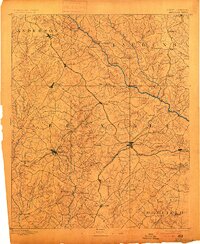 1892 Abbeville1900 Print · USGSCovers Greenwood, including Laurens, Abbeville, and other nearby areas4 unique versions available
 - 1949 Map of Ninety-Six
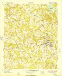 1949 Ninety-Six1949 Print · USGSCovers Greenwood, including Ninety Six, Country Homes, and other nearby areas2 unique versions available
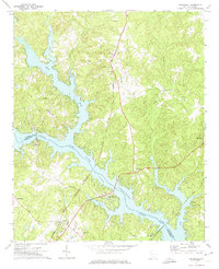
 - 1949 Map of Greenwood
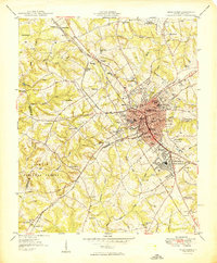 1949 Greenwood1949 Print · USGSCovers Greenwood, including Westover, Hyde Park, and other nearby areas
 - 1954 Map of Greenville, 1965 Print
 1954 Greenville1965 Print · USGSCovers Greenwood, including Athens, Greenville, and other nearby areas2 unique versions available
 - 1958 Map of Greenville
 1958 Greenville1958 Print · USGSCovers Greenwood, including Athens, Greenville, and other nearby areas
 - 1971 Map of Cokesbury, 1974 Print
 1971 Cokesbury1974 Print · USGSCovers Greenwood, including Hodges, Roman Acres, and other nearby areas2 unique versions available
 - 1971 Map of Waterloo, 1975 Print
 1971 Waterloo1975 Print · USGSCovers Greenwood, including Cross Hill, Waterloo, and other nearby areas
 - 1978 Map of Greenwood, 1979 Print
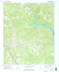
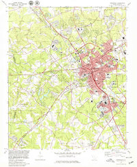 1978 Greenwood1979 Print · USGSCovers Greenwood, including Westover, Hyde Park, and other nearby areas
 - 1978 Map of Ninety-Six, 1979 Print
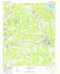 1978 Ninety-Six1979 Print · USGSCovers Greenwood, including Ninety Six, Country Homes, and other nearby areas
 - 1979 Map of Abbeville, 1980 Print
 1979 Abbeville1980 Print · USGSCovers Greenwood, including Anderson, Laurens, and other nearby areas2 unique versions available
End of results
Showing maps 1-10 of 10
Top cities near Greenwood
- Abbeville historical maps
- Honea Path historical maps
- Ninety Six historical maps
- Due West historical maps
- Cross Hill historical maps
- Donalds historical maps
See more
Top neighborhoods of Greenwood
- Wade Heights historical maps
- Rock Creek historical maps
- Smithfield historical maps
- South Greenwood historical maps
- Stalnaker Heights historical maps
- Wisewood historical maps
See more
Frequently asked questions
- What are the different types of historical maps available for Greenwood?
- What is the oldest map of Greenwood?
- Where can I purchase historical maps of Greenwood for my home or office?
- Where can I download high-res historical maps of Greenwood?
- Are there historical topographic maps available for Greenwood?
- Is there historical aerial imagery available for Greenwood?
- Where are historical maps of Greenwood sourced from?