
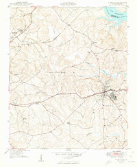
1949 Map of Ninety-Six
USGS Topo · Published 1949About this map
Ninety-Six serves as the focal point of this late-1940s landscape, where the confluence of the Southern and Seaboard Air Line railroads highlights its importance as a regional transportation hub. The geography is defined by a dense network of tributaries including Ninety-Six Creek, Wilson Creek, and Coronaca Creek that flow toward the Saluda River and the newly created Lake Greenwood at the northern edge.
Find a feature on this map
30 named features on this map. Tap any name to fly to it.
Don’t see what you’re looking for? This feature index may not catch every label — zoom into the map to look around manually.
Map Details
Editions of this 1949 Ninety-Six Map
2 editions found
Other maps of this area

1892 · Abbeville
USGS Topo · 1:125,000

1908 · Kirksey
USGS Topo · 1:24,000

1941 · Spartanburg
USGS Topo · 1:250,000

1949 · Greenwood
USGS Topo · 1:24,000

1950 · Bradley
USGS Topo · 1:24,000

1950 · Kirksey
USGS Topo · 1:24,000

1953 · Spartanburg
USGS Topo · 1:250,000

1954 · Greenville
USGS Topo · 1:250,000

1958 · Greenville
USGS Topo · 1:250,000

1960 · Spartanburg
USGS Topo · 1:250,000