1980s Maps of Hampton, South Carolina
Explore 5 historic maps of Hampton from the 1980s. These maps offer a rare glimpse into what life looked like during the 1980s — showing old roads, neighborhoods, homes, and landmarks that have changed or disappeared over time.
Whether you're researching your family's past, planning a metal detecting trip, or studying how Hampton's landscape evolved across the 1980s, these high-resolution maps are a powerful tool for exploring the history of this region.
- Focus on a specific era: All maps on this page are from the 1980s, giving you a focused view of this time period.
- See what’s changed: Compare century-old streets, trails, and buildings to today's modern landscape using overlays and satellite layers.
- Research with precision: Use these maps for genealogy, historical research, land use analysis, or educational projects.
- View, download, or print: Maps are fully viewable online in high resolution, and can be downloaded or printed for your own records.
Start exploring Hampton's history through authentic maps from the 1980s. This is your window into the past.
Hampton, SC maps
(5)- 1981 Map of Sylvania, 1982 Print
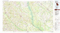 1981 Sylvania1982 Print · USGSThe Georgia and South Carolina borderlands appear in the early 1980s, centered on the river-fed swamps and railroad towns between Sylvania and Estill. Trace family roots and vanished infrastructure along the Central of Georgia line or near Magnolia Springs State Park.
 - 1988 Map of Hampton
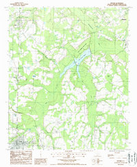
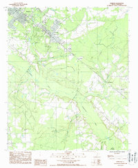 1988 Hampton1988 Print · USGSHampton County in the late 1980s reveals a classic Lowcountry landscape defined by the winding Coosawhatchie River and its many branches. Researchers can trace the development of Hampton and Varnville or locate family landmarks near Lowndes Lake and Almeda.
 - 1988 Map of Fairfax
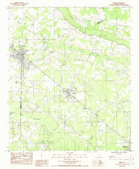 1988 Fairfax1988 Print · USGSThe borderlands of Allendale and Hampton Counties come into focus in the late eighties, centered on the historic rail-and-road junctions of Fairfax and Brunson. Genealogists and local historians can trace family-named water bodies like Jackson Branch or locate rural sites such as Halls Mill and Dukes.
 - 1988 Map of Crocketville
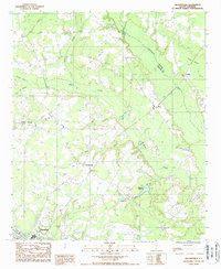 1988 Crocketville1988 Print · USGSHampton County and the Salkehatchie River basin are shown here in the late 1980s as the region maintained its rural character and wetland-dependent economy. Researchers can trace local family landmarks and community centers like Cleland Crossroads, Crocketville, and the historic Maulding Millpond.
 - 1988 Map of Gifford
 1988 Gifford1988 Print · USGSHampton County's rural landscape is captured here in the late twentieth century as the region balanced its marshy wetlands with established small-town centers. Genealogists and local historians can trace the foundations of Gifford, Luray, and Estill alongside landmarks like Lake Warren State Park and old railroad grades.
End of results
Showing maps 1-5 of 5
Top cities near Hampton
- Allendale historical maps
- Fairfax historical maps
- Estill historical maps
- Varnville historical maps
- Brunson historical maps
- Ehrhardt historical maps
See more
Frequently asked questions
- What are the different types of historical maps available for Hampton?
- What is the oldest map of Hampton?
- Where can I purchase historical maps of Hampton for my home or office?
- Where can I download high-res historical maps of Hampton?
- Are there historical topographic maps available for Hampton?
- Is there historical aerial imagery available for Hampton?
- Where are historical maps of Hampton sourced from?