1930s Maps of Kershaw County, South Carolina
Explore 5 historic maps of Kershaw County from the 1930s. These maps offer a rare glimpse into what life looked like during the 1930s — showing old roads, neighborhoods, homes, and landmarks that have changed or disappeared over time.
Whether you're researching your family's past, planning a metal detecting trip, or studying how Kershaw County's landscape evolved across the 1930s, these high-resolution maps are a powerful tool for exploring the history of this region.
- Focus on a specific era: All maps on this page are from the 1930s, giving you a focused view of this time period.
- See what’s changed: Compare century-old streets, trails, and buildings to today's modern landscape using overlays and satellite layers.
- Research with precision: Use these maps for genealogy, historical research, land use analysis, or educational projects.
- View, download, or print: Maps are fully viewable online in high resolution, and can be downloaded or printed for your own records.
Start exploring Kershaw County's history through authentic maps from the 1930s. This is your window into the past.
Kershaw County, SC maps
(5)- 1935 Map of Camden
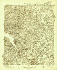 1935 Camden1935 Print · USGSCamden and the Wateree River basin are captured here in the mid-1930s, showing a region balanced between traditional river-powered mills and new infrastructure. Genealogists can trace family footprints near rural landmarks like Rabon Cross Roads, Kirkley Mill, and the Baron de Kalb Sch.2 unique versions available
 - 1935 Map of Killian
 1935 Killian1935 Print · USGSRichland County at the height of the mid-1930s is a landscape of rural schoolhouses and growing military infrastructure. Genealogists can trace family landmarks like Kelley Cem, Bookman Mill, and dozens of local churches including Roundtop Ch.2 unique versions available
 - 1937 Map of Killian
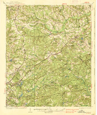 1937 Killian1937 Print · USGSRichland and Kershaw counties in the mid-1930s show a landscape of growing military installations and rural community life. Genealogists can trace family names through dozens of landmarks like Bookmans Mill, Sand Level Sch, and Union Baptist Ch.4 unique versions available
 - 1938 Map of Camden
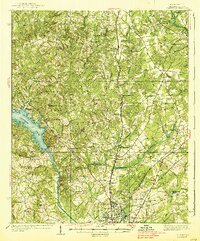 1938 Camden1938 Print · USGSMid-century Kershaw County comes alive here, showing the river-and-rail economy of the 1930s before modern development altered the landscape. Genealogists can trace family roots at Rabon Crossroads, Westville, and the many rural sites like Knight Hill Sch.2 unique versions available
 - 1938 Map of Hagood
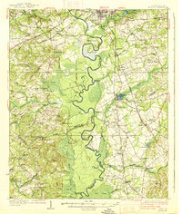 1938 Hagood1938 Print · USGSThe Wateree River basin comes to life in this pre-war study of the Kershaw and Sumter county borderlands. Researchers can trace the river's old crossings and mills at Ancrum Ferry and Boykin Mill Pond, alongside historic schools like Kershaw Industrial Sch.3 unique versions available
End of results
Showing maps 1-5 of 5
Top cities of Kershaw County
Frequently asked questions
- What are the different types of historical maps available for Kershaw County?
- What is the oldest map of Kershaw County?
- Where can I purchase historical maps of Kershaw County for my home or office?
- Where can I download high-res historical maps of Kershaw County?
- Are there historical topographic maps available for Kershaw County?
- Is there historical aerial imagery available for Kershaw County?
- Where are historical maps of Kershaw County sourced from?