1940s Maps of Oconee County, South Carolina
Explore 4 historic maps of Oconee County from the 1940s. These maps offer a rare glimpse into what life looked like during the 1940s — showing old roads, neighborhoods, homes, and landmarks that have changed or disappeared over time.
Whether you're researching your family's past, planning a metal detecting trip, or studying how Oconee County's landscape evolved across the 1940s, these high-resolution maps are a powerful tool for exploring the history of this region.
- Focus on a specific era: All maps on this page are from the 1940s, giving you a focused view of this time period.
- See what’s changed: Compare century-old streets, trails, and buildings to today's modern landscape using overlays and satellite layers.
- Research with precision: Use these maps for genealogy, historical research, land use analysis, or educational projects.
- View, download, or print: Maps are fully viewable online in high resolution, and can be downloaded or printed for your own records.
Start exploring Oconee County's history through authentic maps from the 1940s. This is your window into the past.
Oconee County, SC maps
(4)- 1946 Map of Reid, 1956 Print
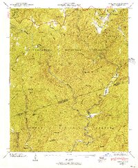 1946 Reid1956 Print · USGSThe high mountain country of the Blue Ridge is documented here in the mid-1940s, just as the national forests were maturing. Genealogists and hikers can trace the remote Oakland Cem, the tiny settlement of Cane Brake, and the old rail path of the Southern Railway.4 unique versions available
 - 1946 Map of Cashiers, 1957 Print
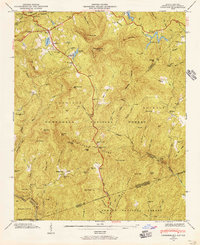 1946 Cashiers1957 Print · USGSJackson County high country comes alive in the mid-1940s, showcasing the intersection of the Blue Ridge and the Tennessee Divide. Genealogists and historians can locate family landmarks like Upper Zachary Cem, Montvale Sch, and the community of Grimshawes.5 unique versions available
 - 1947 Map of Reid
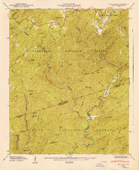 1947 Reid1947 Print · USGSThe Blue Ridge mountains at the North and South Carolina border are captured here in the late 1940s, showing a land defined by national forests and river gorges. Researchers can locate the Oakland Cem, trace the Thompson River, and find remote landmarks like Musterground Mtn.
 - 1947 Map of Cashiers
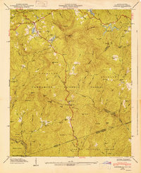 1947 Cashiers1947 Print · USGSThe Blue Ridge high country of Jackson County is meticulously detailed here in the late 1940s, centered on the Cashiers plateau. Genealogists can locate family sites like Upper Zachary Cem, the rural Montvale Sch, and the remote junction at Ellicott Rock.2 unique versions available
End of results
Showing maps 1-4 of 4
Top cities of Oconee County
- Seneca historical maps
- Walhalla historical maps
- Westminster historical maps
- West Union historical maps
- Salem historical maps
Frequently asked questions
- What are the different types of historical maps available for Oconee County?
- What is the oldest map of Oconee County?
- Where can I purchase historical maps of Oconee County for my home or office?
- Where can I download high-res historical maps of Oconee County?
- Are there historical topographic maps available for Oconee County?
- Is there historical aerial imagery available for Oconee County?
- Where are historical maps of Oconee County sourced from?