1950s Maps of Oconee County, South Carolina
Explore 15 historic maps of Oconee County from the 1950s. These maps offer a rare glimpse into what life looked like during the 1950s — showing old roads, neighborhoods, homes, and landmarks that have changed or disappeared over time.
Whether you're researching your family's past, planning a metal detecting trip, or studying how Oconee County's landscape evolved across the 1950s, these high-resolution maps are a powerful tool for exploring the history of this region.
- Focus on a specific era: All maps on this page are from the 1950s, giving you a focused view of this time period.
- See what’s changed: Compare century-old streets, trails, and buildings to today's modern landscape using overlays and satellite layers.
- Research with precision: Use these maps for genealogy, historical research, land use analysis, or educational projects.
- View, download, or print: Maps are fully viewable online in high resolution, and can be downloaded or printed for your own records.
Start exploring Oconee County's history through authentic maps from the 1950s. This is your window into the past.
Oconee County, SC maps
(15)- 1950 Map of La France, 1964 Print
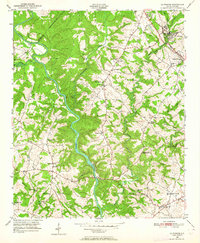 1950 La France1964 Print · USGSAnderson County's rural communities and river crossings are captured here at the start of the 1950s. Genealogists and local historians can trace family roots through numerous sites like Holly Springs Ch, Portman Dam, and the Blue Ridge RR.2 unique versions available
 - 1951 Map of La France
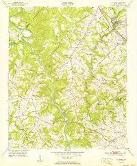 1951 La France1951 Print · USGSAnderson County in the early fifties is captured here as a landscape of tight-knit rural communities and vital river crossings. Researchers can trace ancestral locations through numerous sites like Sandy Springs, Asbury Clark Memorial Ch, and Earles Bridge.2 unique versions available
 - 1951 Map of Clemson, 1952 Print
 1951 Clemson1952 Print · USGSThe foothills of South Carolina come to life in the early fifties, centered on the growing campus of Clemson Agricultural College. Researchers can trace the Southern rail line through Central or locate family landmarks like Lawrence Chapel and Mt Zion Cem.6 unique versions available
 - 1954 Map of Greenville, 1965 Print
 1954 Greenville1965 Print · USGSThe Upstate and Northeast Georgia are captured here during a decade of massive transformation as new reservoirs reshaped the Piedmont. Genealogists and hikers can trace the Appalachian Trail over Brasstown Bald or locate old community centers like Demorest, Westminster, and Royston.3 unique versions available
 - 1955 Map of Knoxville
 1955 Knoxville1955 Print · USGSThe Southern Appalachians and the Smoky Mountains are shown here at a peak of mid-century development and conservation. Genealogists and historians can trace the early road networks connecting Gatlinburg, Waynesville, and the Cherokee Indian Reservation across the high ridges.
 - 1957 Map of Tugaloo Lake, 1958 Print
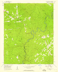
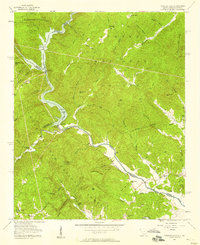 1957 Tugaloo Lake1958 Print · USGSThe river borders of Georgia and South Carolina come alive in the 1950s as they wind through the deep mountain forests of Rabun and Oconee counties. Researchers can trace the hydroelectric developments at Tugaloo Lake or locate family landmarks like Prather Bridge and Old Liberty Ch.4 unique versions available
 - 1957 Map of Rainy Mountain, 1958 Print
 1957 Rainy Mountain1958 Print · USGSThe border between Georgia and South Carolina is defined by the winding Chattooga River during the late 1950s. Researchers can trace rural life and mountain genealogies through landmarks like Godfrey Cem, Longcreek, and the Rainy Mtn Camp.4 unique versions available
 - 1957 Map of Knoxville, 1966 Print
 1957 Knoxville1966 Print · USGSThe Southern Appalachians of Tennessee and North Carolina are mapped here during the mid-twentieth century as new highways reached the high country. Genealogists and historians can trace the topography between Knoxville and Asheville, locating family landmarks near Fontana Lake or along the Blue Ridge Parkway.4 unique versions available
 - 1958 Map of Greenville
 1958 Greenville1958 Print · USGSThe Piedmont and Blue Ridge foothills come alive in this mid-century survey of the Upstate and Northeast Georgia. Trace the regional rail-and-river economy through the Southern Railway corridors and early reservoir developments like Lake Sidney Lanier.
 - 1958 Map of Seneca, 1961 Print
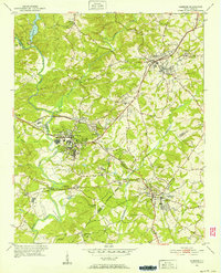
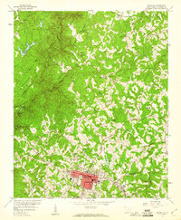
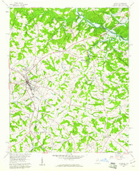
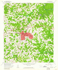 1958 Seneca1961 Print · USGSOconee County stands at the brink of transformation in the late fifties as the Hartwell Reservoir begins to flood the river valleys. Genealogists and historians can trace the footprint of Seneca and Utica alongside rural landmarks like Mt Nebo Ch and Newry-Corinth Sch.3 unique versions available
 - 1958 Map of Fair Play, 1963 Print
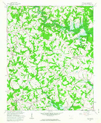 1958 Fair Play1963 Print · USGSThe Oconee and Anderson county border is captured here during the late fifties as the rising waters of the Hartwell Reservoir began to alter the landscape. Genealogists can trace local landmarks like Old Hephzibah Ch, Fork Sch, and the rural community at Earles Grove.4 unique versions available
 - 1959 Map of Salem, 1960 Print
 1959 Salem1960 Print · USGSThe foothills of the Blue Ridge Mountains appear here in the late fifties, defined by the river valleys of the Whitewater and Toxaway. Researchers can trace the original locations of Jocassee, Chapman Bridge, and McKinney Chapel before the basin was flooded.5 unique versions available
 - 1959 Map of Walhalla, 1960 Print
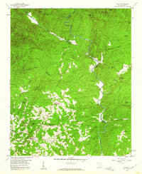
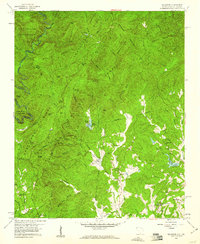
 1959 Walhalla1960 Print · USGSThe foothills of Oconee County come alive in the late fifties, showing the growth of Walhalla and the rugged peaks of the Blue Ridge. Researchers can trace the legendary Stumphouse Mtn Tunnel and local landmarks like Oconee Station.5 unique versions available
 - 1959 Map of Tamassee, 1960 Print
 1959 Tamassee1960 Print · USGSOconee County mountain life at the end of the fifties is defined here by its winding river borders and scattered forest missions. You can trace family roots at Winchester Cem or locate historic sites like the Tamassee DAR Sch and Village Creek Mission.3 unique versions available
 - 1959 Map of Lavonia, 1961 Print
 1959 Lavonia1961 Print · USGSNortheast Georgia stands at the edge of a major geographic shift in the late fifties as the Tugaloo River valley prepares for inundation. Researchers can trace the original rail lines of the Southern Railway and locate local landmarks like Parkertown Mill and Willis Chapel before the waters of Hartwell Reservoir rose.2 unique versions available
End of results
Showing maps 1-15 of 15
Top cities of Oconee County
- Seneca historical maps
- Walhalla historical maps
- Westminster historical maps
- West Union historical maps
- Salem historical maps
Frequently asked questions
- What are the different types of historical maps available for Oconee County?
- What is the oldest map of Oconee County?
- Where can I purchase historical maps of Oconee County for my home or office?
- Where can I download high-res historical maps of Oconee County?
- Are there historical topographic maps available for Oconee County?
- Is there historical aerial imagery available for Oconee County?
- Where are historical maps of Oconee County sourced from?