
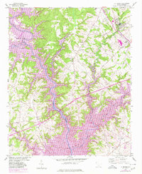
1950 Map of La France
USGS Topo · Published 1964About this map
The Seneca River winds through this 1950s South Carolina landscape, carving a boundary between Oconee and Anderson counties. The rural character of the region is defined by a dense network of country churches and community schools, such as Holly Springs Ch and New Light Sch, which served as the social anchors for scattered farmsteads. Industrial and infrastructure footprints are evident at La France near Millwee Creek and further south at Portman Dam.
Find a feature on this map
49 named features on this map. Tap any name to fly to it.
Don’t see what you’re looking for? This feature index may not catch every label — zoom into the map to look around manually.
Map Details
Editions of this 1950 La France Map
2 editions found
Other maps of this area

1888 · Pickens
USGS Topo · 1:125,000

1893 · Elberton
USGS Topo · 1:125,000

1894 · Pickens
USGS Topo · 1:125,000

1951 · La France
USGS Topo · 1:24,000

1951 · Clemson
USGS Topo · 1:24,000

1954 · Greenville
USGS Topo · 1:250,000

1957 · Anderson
USGS Topo · 1:62,500

1958 · Greenville
USGS Topo · 1:250,000

1958 · Seneca
USGS Topo · 1:24,000

1958 · Fair Play
USGS Topo · 1:24,000