
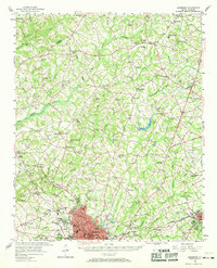
1957 Map of Anderson
USGS Topo · Published 1958About this map
Anderson anchors this Upstate landscape at the end of the 1950s, shown here as a growing hub of education and industry. The presence of Anderson College and the Radio Towers (WANS) reflects the city's mid-century modernization, while its transportation roots are visible in the paths of the Southern and Piedmont and Northern railroads. Outside the urban core, the terrain is defined by a dense network of rural life, evidenced by dozens of community landmarks like the McElmoyle Sch, White Oak Ch, and Friendship Ch. To the northeast, the State Fish Hatchery and Skinner Ridge Lookout Tower stand near the Pickens and Anderson County line, marking a shift toward more wooded and managed lands. The map also captures local recreation and infrastructure, from the East Park Speedway to the Filtration Plant, providing a complete view of the region's social and physical geography.
Find a feature on this map
98 named features on this map. Tap any name to fly to it.
Don’t see what you’re looking for? This feature index may not catch every label — zoom into the map to look around manually.
Map Details
Editions of this 1957 Anderson Map
2 editions found
Other maps of this area

1888 · Pickens
USGS Topo · 1:125,000

1892 · Abbeville
USGS Topo · 1:125,000

1893 · Elberton
USGS Topo · 1:125,000

1894 · Pickens
USGS Topo · 1:125,000

1935 · Greenville
USGS Topo · 1:48,000

1938 · Greenville
USGS Topo · 1:62,500

1950 · La France
USGS Topo · 1:24,000

1951 · La France
USGS Topo · 1:24,000

1951 · Clemson
USGS Topo · 1:24,000

1954 · Greenville
USGS Topo · 1:250,000