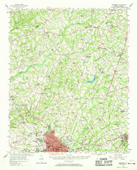
1957 Map of Anderson
USGS Topo · Published 1969About this map
The city of Anderson anchors this mid-century portrait of the South Carolina Upstate, revealing a landscape defined by traditional community anchors and emerging infrastructure. Education and healthcare are prominent in the urban core, notably at Anderson College and St Marys Hospital, while the surrounding countryside is densely patterned with rural institutions. A striking number of family-named landmarks and rural congregations like Pickens Chapel, Fairfield Ch, and Sharon Ch suggest a deeply rooted social geography. The terrain is carved by a complex network of waterways, including Three and Twenty Creek and Beaverdam Creek, which dictated the early settlement patterns of crossroads like Piercetown and Five Forks. Beyond the town center, specialized land uses such as the State Fish Hatchery and the Stribling Ridge Lookout Tower reflect the diverse state of regional development before widespread suburbanization reached these outlying communities.
Find a feature on this map
106 named features on this map. Tap any name to fly to it.
Don’t see what you’re looking for? This feature index may not catch every label — zoom into the map to look around manually.
Map Details
Editions of this 1957 Anderson Map
2 editions found

Other maps of this area

1888 · Pickens
USGS Topo · 1:125,000

1892 · Abbeville
USGS Topo · 1:125,000

1893 · Elberton
USGS Topo · 1:125,000

1894 · Pickens
USGS Topo · 1:125,000

1935 · Greenville
USGS Topo · 1:48,000

1938 · Greenville
USGS Topo · 1:62,500

1950 · La France
USGS Topo · 1:24,000

1951 · La France
USGS Topo · 1:24,000

1951 · Clemson
USGS Topo · 1:24,000

1954 · Greenville
USGS Topo · 1:250,000