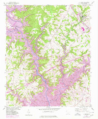
1950 Map of La France
USGS Topo · Published 1980About this map
Hartwell Lake dominates the landscape at the boundary of Oconee and Anderson counties, where the Seneca River and its numerous tributaries have been shaped by the reservoir's controlled inundation levels. The area surrounding the textile mill village of La France and the community of Sandy Springs is dense with local history, featuring an extensive network of rural churches and schools. Genealogists can locate family landmarks such as the Smith Chapel Cem and Holly Springs Cem, alongside historic school sites like New Light Sch and Zion Sch. The terrain is defined by its water system, with Eighteenmile Creek and Three and Twenty Creek feeding into the larger basin. Road developments are evident through the marked interchanges and the presence of a Rest Area, showing the modernization of the corridor while local landmarks like Masons Crossroads and Prichards anchor the community's traditional geography.
Find a feature on this map
42 named features on this map. Tap any name to fly to it.
Don’t see what you’re looking for? This feature index may not catch every label — zoom into the map to look around manually.
Map Details
Editions of this 1950 La France Map
2 editions found
Other maps of this area

1888 · Pickens
USGS Topo · 1:125,000

1893 · Elberton
USGS Topo · 1:125,000

1894 · Pickens
USGS Topo · 1:125,000

1950 · La France
USGS Topo · 1:24,000

1951 · La France
USGS Topo · 1:24,000

1951 · Clemson
USGS Topo · 1:24,000

1954 · Greenville
USGS Topo · 1:250,000

1957 · Anderson
USGS Topo · 1:62,500

1958 · Greenville
USGS Topo · 1:250,000

1958 · Seneca
USGS Topo · 1:24,000