1940s Maps of Liberia, South Carolina
Explore 2 historic maps of Liberia from the 1940s. These maps offer a rare glimpse into what life looked like during the 1940s — showing old roads, neighborhoods, homes, and landmarks that have changed or disappeared over time.
Whether you're researching your family's past, planning a metal detecting trip, or studying how Liberia's landscape evolved across the 1940s, these high-resolution maps are a powerful tool for exploring the history of this region.
- Focus on a specific era: All maps on this page are from the 1940s, giving you a focused view of this time period.
- See what’s changed: Compare century-old streets, trails, and buildings to today's modern landscape using overlays and satellite layers.
- Research with precision: Use these maps for genealogy, historical research, land use analysis, or educational projects.
- View, download, or print: Maps are fully viewable online in high resolution, and can be downloaded or printed for your own records.
Start exploring Liberia's history through authentic maps from the 1940s. This is your window into the past.
Liberia, SC maps
(2)- 1946 Map of Table Rock, 1965 Print
 1946 Table Rock1965 Print · USGSPickens County and the Blue Ridge escarpment are documented here in the mid-1940s, showing the early infrastructure of Table Rock State Park. Researchers can trace old mountain schoolhouses like Rock Sch and family burial sites at Cassell Cems.5 unique versions available
 - 1947 Map of Table Rock
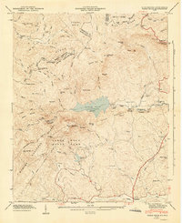 1947 Table Rock1947 Print · USGSPickens County and the Blue Ridge escarpment appear here just after the war, showing the mountain landscape before modern development. Genealogists can locate family landmarks like Cassell Cems or trace rural education at Rock Sch and New Town Sch.2 unique versions available
End of results
Showing maps 1-2 of 2
Top cities near Liberia
- Greenville historical maps
- Easley historical maps
- Brevard historical maps
- Travelers Rest historical maps
- Liberty historical maps
- Pickens historical maps
See more
Frequently asked questions
- What are the different types of historical maps available for Liberia?
- What is the oldest map of Liberia?
- Where can I purchase historical maps of Liberia for my home or office?
- Where can I download high-res historical maps of Liberia?
- Are there historical topographic maps available for Liberia?
- Is there historical aerial imagery available for Liberia?
- Where are historical maps of Liberia sourced from?