1970s Maps of Five Points, Columbia
Explore 2 historic maps of Five Points from the 1970s. These maps offer a rare glimpse into what life looked like during the 1970s — showing old roads, neighborhoods, homes, and landmarks that have changed or disappeared over time.
Whether you're researching your family's past, planning a metal detecting trip, or studying how Five Points's landscape evolved across the 1970s, these high-resolution maps are a powerful tool for exploring the history of this region.
- Focus on a specific era: All maps on this page are from the 1970s, giving you a focused view of this time period.
- See what’s changed: Compare century-old streets, trails, and buildings to today's modern landscape using overlays and satellite layers.
- Research with precision: Use these maps for genealogy, historical research, land use analysis, or educational projects.
- View, download, or print: Maps are fully viewable online in high resolution, and can be downloaded or printed for your own records.
Start exploring Five Points's history through authentic maps from the 1970s. This is your window into the past.
Five Points, Columbia maps
(2)- 1972 Map of Columbia North, 1973 Print
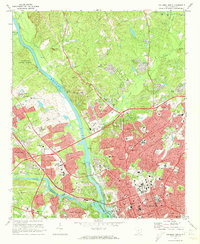 1972 Columbia North1973 Print · USGSThe South Carolina capital and its river forks are captured here in the early seventies, just as suburban growth reached northward into Eau Claire. Researchers can trace the grounds of Benedict College, Allen Univ, and the historic Elmwood Cemetery.4 unique versions available
 - 1972 Map of Southwest Columbia, 1975 Print
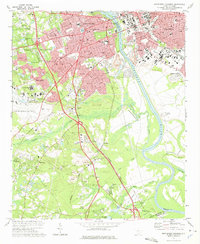 1972 Southwest Columbia1975 Print · USGSGreater Columbia in the early seventies shows a landscape of rapid suburban expansion balanced against the industrial Congaree riverfront. Researchers can trace the mid-century layout of the Columbia Metropolitan Airport, the Columbia Speedway, and local landmarks like Mt Pisgah Ch.2 unique versions available
End of results
Showing maps 1-2 of 2
Top cities near Five Points
- Columbia historical maps
- Lexington historical maps
- West Columbia historical maps
- Cayce historical maps
- Forest Acres historical maps
- Blythewood historical maps
See more
Top neighborhoods of Five Points
Frequently asked questions
- What are the different types of historical maps available for Five Points?
- What is the oldest map of Five Points?
- Where can I purchase historical maps of Five Points for my home or office?
- Where can I download high-res historical maps of Five Points?
- Are there historical topographic maps available for Five Points?
- Is there historical aerial imagery available for Five Points?
- Where are historical maps of Five Points sourced from?