1970s Maps of Sims, Columbia
Explore 1 historic maps of Sims from the 1970s. These maps offer a rare glimpse into what life looked like during the 1970s — showing old roads, neighborhoods, homes, and landmarks that have changed or disappeared over time.
Whether you're researching your family's past, planning a metal detecting trip, or studying how Sims's landscape evolved across the 1970s, these high-resolution maps are a powerful tool for exploring the history of this region.
- Focus on a specific era: All maps on this page are from the 1970s, giving you a focused view of this time period.
- See what’s changed: Compare century-old streets, trails, and buildings to today's modern landscape using overlays and satellite layers.
- Research with precision: Use these maps for genealogy, historical research, land use analysis, or educational projects.
- View, download, or print: Maps are fully viewable online in high resolution, and can be downloaded or printed for your own records.
Start exploring Sims's history through authentic maps from the 1970s. This is your window into the past.
Sims, Columbia maps
(1)- 1972 Map of Fort Jackson South, 1973 Print
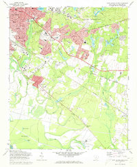 1972 Fort Jackson South1973 Print · USGSRichland County undergoes significant postwar expansion in the early seventies as the capital city grows toward the military boundary. Genealogists and historians can trace local landmarks like Greenlawn Memorial Park, Zion Chapel No 2 Ch, and the rail stops at Lykes and Hopkins.3 unique versions available
End of results
Showing maps 1-1 of 1
Top cities near Sims
- Columbia historical maps
- Lexington historical maps
- West Columbia historical maps
- Cayce historical maps
- Forest Acres historical maps
- Blythewood historical maps
See more
Frequently asked questions
- What are the different types of historical maps available for Sims?
- What is the oldest map of Sims?
- Where can I purchase historical maps of Sims for my home or office?
- Where can I download high-res historical maps of Sims?
- Are there historical topographic maps available for Sims?
- Is there historical aerial imagery available for Sims?
- Where are historical maps of Sims sourced from?