1970s Maps of Union County, South Carolina
Explore 3 historic maps of Union County from the 1970s. These maps offer a rare glimpse into what life looked like during the 1970s — showing old roads, neighborhoods, homes, and landmarks that have changed or disappeared over time.
Whether you're researching your family's past, planning a metal detecting trip, or studying how Union County's landscape evolved across the 1970s, these high-resolution maps are a powerful tool for exploring the history of this region.
- Focus on a specific era: All maps on this page are from the 1970s, giving you a focused view of this time period.
- See what’s changed: Compare century-old streets, trails, and buildings to today's modern landscape using overlays and satellite layers.
- Research with precision: Use these maps for genealogy, historical research, land use analysis, or educational projects.
- View, download, or print: Maps are fully viewable online in high resolution, and can be downloaded or printed for your own records.
Start exploring Union County's history through authentic maps from the 1970s. This is your window into the past.
Union County, SC maps
(3)- 1970 Map of Whitmire North, 1973 Print
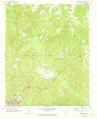 1970 Whitmire North1973 Print · USGSUnion County during the early 1970s shows a landscape of deep forests and river valleys shaped by the Tyger River. Researchers can trace the legacy of rural communities through sites like Goshen Hill, the Carlisle-Santuc Sch, and several remote family cemeteries.
 - 1971 Map of Union East, 1974 Print
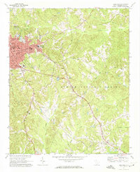 1971 Union East1974 Print · USGSThe city of Union and the industrial village of Monarch are captured here in the early 1970s. Genealogists can trace family names and local landmarks like Sardis Ch, Santuc, and Forest Lawn Cem along the Southern railroad.
 - 1972 Map of Lockhart, 1975 Print
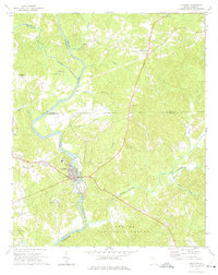 1972 Lockhart1975 Print · USGSThe river-driven economies of the Carolina Piedmont are on display in the early 1970s at the confluence of the Broad River and Pacolet River. Genealogists and local historians can trace family-named landmarks and rural congregations like Mt Hopewell Ch, Bullock Creek, and the historic site of Pinckneyville.2 unique versions available
End of results
Showing maps 1-3 of 3
Top cities of Union County
- Union historical maps
- Jonesville historical maps
- Carlisle historical maps
- Lockhart historical maps
- Shady Grove historical maps
- Adams Ford historical maps
Frequently asked questions
- What are the different types of historical maps available for Union County?
- What is the oldest map of Union County?
- Where can I purchase historical maps of Union County for my home or office?
- Where can I download high-res historical maps of Union County?
- Are there historical topographic maps available for Union County?
- Is there historical aerial imagery available for Union County?
- Where are historical maps of Union County sourced from?